Tomer’s Take: The atmospheric river continues through 1/7. The next surge 12/30-1/1 is ‘moderate to strong’ intensity. Feet of grand total snow.
My forecast video 12/29:
Current Setup
Infrared satellite shows the Pineapple Express and parade of storm systems lined-up through 1/7.

Forecast Pattern
Forecast jet stream valid 1/6 shows the west to east jet stream continuing to act like a moisture conveyor belt.

Forecast Timing
Forecast radar/satellite valid 12/29-1/3.
Forecast Totals
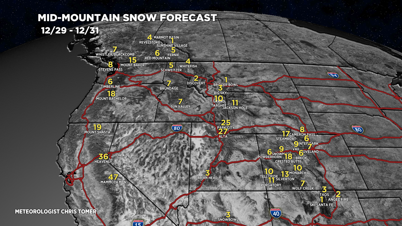
Forecast snow totals (inches) valid 12/29-12/31.

Forecast snow totals (inches) valid 1/1-1/7.

Forecast grand totals 12/29-1/7:
Mammoth Mountain, CA: 95″
Tahoe/Palisade/Kirkwood: 99″
Alta, UT: 57″
Jackson Hole, WY: 29″
Steamboat, CO: 34″
Crested Butte, CO: 37″
Aspen/Snowmass, CO: 21″
Wolf Creek, CO: 37″
Forecast snow timeline for the Wasatch:
- 12/29: 0″
- 12/30: 6″
- 12/31: 21″
- 1/1: 18″
- 1/2: 0″
- 1/3: 0″
- 1/4: 2″
- 1/5: 6″
- 1/6: 2″
- 1/7: 2″
Forecast snow totals (inches) valid 12/29-1/7.


Hi Chris, can you give color on trail running conditions around Moab and Grand Canyon across Jan 1 through Jan 7 cycle? Seems these continuing storms are relatively warm so wonder of rain or snow in Moab and CG Rim? Thanks
Hi Rick, I’ll address this in tomorrow’s update…happy to do it!
Chris
Hi Rick – I just added my forecast for Moab-GC to today’s blog update. Chris
Will all of this moisture be deposited in the mountains or will some of it reach the plains to the east?
The next chance for snow in Denver/I-25 is late Sunday through Monday. Chris
From all of us here in Northern Arizona….thanks for including the AZ Snowbowl!!!
Thanks, Ryan!