Tomer’s Take: The main storm system of the period sets up as an ABQ low delivering deep snow bullseyes 2/21-2/22 along with colder air and strong jet wind. Then a cut-off low in CA moves east 2/23-2/26 through the Southern Tier. A third low delivers heavy snow to CA’s Sierra 2/27-3/1.
10″ in 24 hours at Jackson Hole. That makes it 24″ in 72 hours!

Current Pattern
Water vapor shows the main storm system diving south through the Rockies with strong jet support and colder air.

Forecast Pattern
Forecast jet stream valid 3/1. A trough with heavy Sierra snow is moving east.

Forecast Timing
Forecast radar/satellite valid 2/21-2/26.
Jackson Hole, WY
2/21: 9″
2/22: 4″
2/23: 5″
2/24: 1″
2/25: 0″
2/26: 6″
2/27: 3″
2/28: 3″
3/1: 3″
3/2: 1″
Brighton, UT
2/21: PM 18″
2/22: 14″
2/23: 2″
2/24: 2″
2/25: 1″
2/26: 3″
2/27: 1″
2/28: 0″
3/1: 3″
Telluride, CO
2/21: Late 1″
2/22: 16″
2/23: 4″
2/24: 4″
2/25: 0″
2/26: 6″
3/2: 6″
Kirkwood, CA
2/21: 8″
2/22: 4″
2/23: 5″
2/24: 12″
2/25: 5″
2/26: 10″
2/27: 14″
2/28: 24″
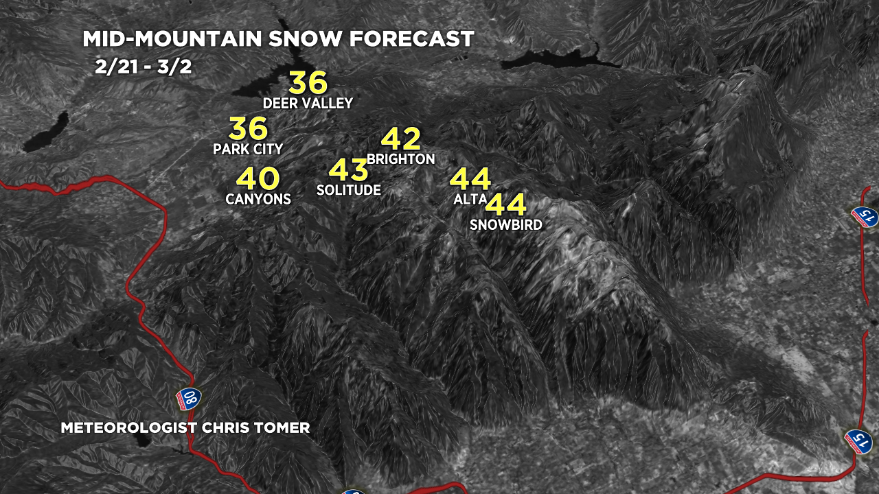
Forecast Totals
2/21-2/23:

2/24-3/2:

2/21-3/2:

2/21-3/2:

2/21-3/2:

2/21-3/2:
VT/NH/ME Snow timeline:
2/21: 1″
2/22: 1″
2/23: 7″
2/24: 1″
2/26: 2″
2/27: 1″
2/28: 6″
3/1: 3″

Wow 11 more inches for Fernie today through thursday! Is that right? They already got 11 inches last night and early this morning
Hi Brett – that’s awesome! No that was the bulk of your accumulation. I could see another 1-3 inches early today. Enjoy!
love the blog..
Does this second storm in to Tahoe continue on beyond March 1st? Coming to Heavenly on March 4th.
Hi Vipul – One storm ends around March 1 then a dry break before another storm system around late 3/3-3/4. So, your timing might work out.
Chris
Hi…I was wondering what you think the weather will be like on the baja peninsula on Pacific side by San Ignacio Lagoon? On 2/28 -3/3
Hi Jennifer –
San Ignacio Lagoon:
2/28: Dry, partly sunny, 69/51F (High/low)
3/1: 10% shower, partly/mostly cloudy, 64/55F.
3/2: Dry, sun, 65/54F.
3/3: Dry, sun, 69/50F.
Chris
Hey Chris!! We are headed to Ruby Mountain Heli Ski 3-2-23 to 3-5-23. You think the Sierra forecast will impact the Rubies?
Now that sounds like fun, Jonathon!
It’s still a ways out but here’s a general look:
3/2: drier
3/3: snow chance, gusty wind 30-50mph.
3/4: snow chance, gusty wind 30-50mph.
3/5: drier
Chris
Hi Chris,
Can I ask you a question about weather on baja peninsula?
Hi Jennifer, I replied below! Chris
Any idea on forecast pattern for 3/2-3/6? Headed to big sky but could change if necessary for more snow?
Hi Casey,
There is a snow chance each of those days at Big Sky. Accumulation appears light each day. It also looks windy. Remind me again as we get closer for an update.