Tomer’s Take:
- Weekend mountain snow remains on track.
- Timeline: 10/22-10/24.
- Beneficiaries: PNW, Banff, ID, MT, WY, UT, CO.
- Strong wind likely 40-85mph across the high peaks of UT, WY, CO.
- Air temps drop 10-25 degrees.
Current Setup
Water vapor satellite shows the parade of low pressure systems that will gradually erode/dislodge the large high pressure ridge. Orange/red = drier air aloft.

Pattern Change
Confidence continues to grow for a complete pattern change this weekend (10/22-10/24).
Below, here’s the forecast mid-atmosphere pressure anomalies valid 10/23.

Forecast Wind Gusts
Let’s first talk forecast wind gusts 10/22-10/24.
| Quandary Peak | Gusts |
| 10/22 | 40 |
| 10/23 | 50 |
| 10/24 | 50 |
| Crestone Peak | Gusts |
| 10/22 | 60 |
| 10/23 | 85 |
| 10/24 | 60 |
| Kings Peak | Gusts |
| 10/22 | 65 |
| 10/23 | 35 |
| 10/24 | 40 |
Forecast Snowfall
Here’s the future radar/satellite valid Saturday 10/22 @9pm.

Sunday 10/23 @5am:

Sunday 10/23 @6:15pm:

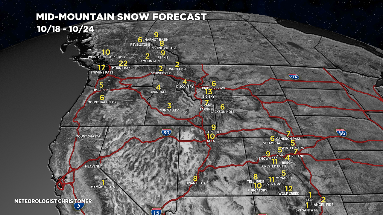
Forecast snow totals (inches) 10/18-10/24:

My forecast video for 10/18:
Yippee little cottonwood canyon is excited!
Ya! Loveland is excited!
Thanks, Jims!
Thanks, Karen!
Let’s start building a base! I’m a little more optimistic this stronger La Nina will send the troughs a little further south than the previous two and give us more consistent snowfall. Fingers crossed!
We shall see, thanks, Jeremiah. Chris