Tomer’s Take:
- Two active periods for mountain snow are possible regulated by a ridge of high pressure.
- Two active periods slightly favor Western Slope zones for higher totals.
- Best accumulation will occur at higher elevations with melting in-between.
- Peak Fall color in Colorado is running behind schedule in some mountain zones.
- My full Winter Forecast can be found here.
October Pattern
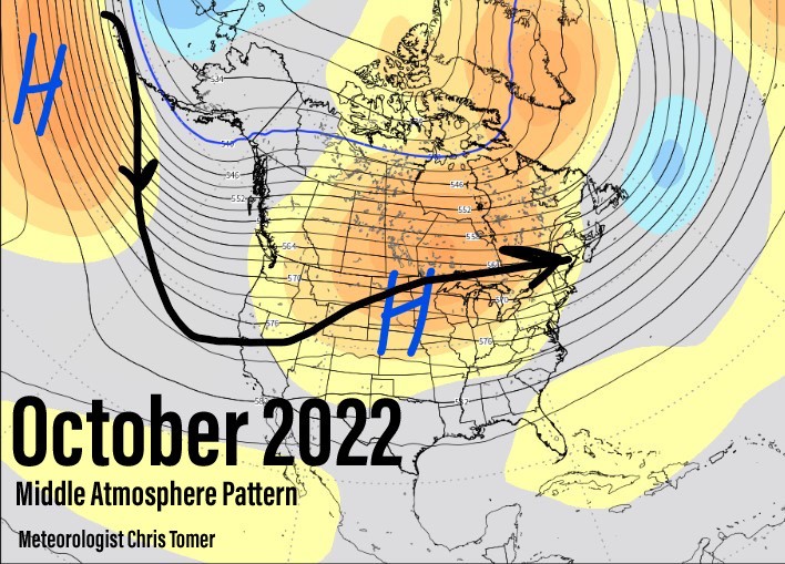
The mid-atmosphere pressure pattern favors the Pacific Northwest/West Coast for above normal precipitation. In Colorado, we’ll get leftovers with high pressure regulating most days.

Snow Forecast
Forecast October grand totals are below. Best accumulation is at higher elevations in these locations. Normally, this snow falls then melts except on the higher peaks. Also, strong wind starts kicking-in with these stormy periods.
| Forecast | Inches |
| Loveland | 12 |
| Wolf Creek | 12 |
| Steamboat/Werner | 12 |
| Collegiate Peaks | 10 |
| Aspen/Snowmass | 13 |
| Winter Park | 12 |
| Mount Elbert | 13 |
| Monarch Pass | 6 |
| Telluride | 8 |
Fall Color Update
Peak Fall Color is running behind schedule in Colorado. Parts of the mountains saw a robust Monsoon season.
Jennifer Broome snapped this photo on 9/22 in Vail:

Some zones like Grand Lake, Berthoud Pass, RMNP, and the Northern Mountains are further along.
John Williams snapped these photos between 9/21-9/22:


