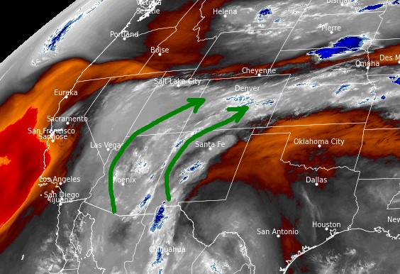
Tomer’s Take:
- Major surge of Monsoon moisture hits AZ, NM, UT, and CO Thursday-Friday.
- In Colorado, this is the largest surge of the season so far.
- In Colorado, the Southern Mountains get hit the hardest. Flash flooding possible starting Wednesday afternoon/night with multiple rounds of thunderstorms.
- Total rainfall by 7/31 could run 1-4 inches in the Southern Mountains of CO.
- Rain/t-storms might continue through the night.
- Brief 14er summit snow possible late Thursday into Friday morning.
7/26 5:30am Water vapor satellite shows the seasonal Monsoon in full swing. Red/orange = drier air aloft.

Surge Forecast
I’ve had numerous forecast requests for late week and weekend from hikers, trail runners, and mountaineers. I’m also looking at longer range trends for Nolan’s.
- This is a major surge for areas south of I-70 in Colorado between Wednesday night and Saturday night. Peak moisture occurs Thursday-Friday.
- I consider Thursday-Friday “no go” days on the 13ers/14ers in the Southern Mountains. But, Wednesday afternoon and Saturday should also be approached with caution as moisture levels stay high.
Forecast Precipitation Chances:
| Mount Eolus | AM | PM |
| 7/27 | 10% | 100% |
| 7/28 | 50% | 100% |
| 7/29 | 90% | 100% |
| 7/30 | 70% | 100% |
| 7/31 | 0% | 50% |
Digital hourly forecast for 13,000ft around Mount Elbert valid 7/28-7/29:

Forecast rain grand totals by 7/31.


Thanks for the forecast. Much needed moisture coming but not good climbing weather. Still looks like lower percent chances north of I-70?
Hi Tim, yes that’s the way I see it too. Chris
Hey Chris. What about lower elevations like segment 1 & 2? Thank you.
Hi Liz – Sections 1-2:
THR: high chance for afternoon rain/t-storms. Flash flooding possible.
FRI: AM dry, PM 80% rain/t-storms.
SAT: drier, 20% PM rain/t-storms.