Tomer’s Take: I typically stop regular ski/snow blog posts after April 1 each season. Going forward, I’ll post less frequently with other topics. In this post I cover Western Snowpack, a look back at my Winter forecast, May 2024 forecast, La Nina Watch, and Summer Monsoon forecast.
THANKS to everyone who stopped by my Blog this Winter!
I’ll keep my YouTube channel snow/ski forecast videos going for a little while longer. I might add forecast videos through the Spring & Summer depending on the weather pattern.
A few interesting items:
Western Snowpack valid 4/10/2024.

For reference, here was my forecast for this Winter (from September 2023):

->Alta, UT ended up with 611″ of snowfall and counting (they close on April 21). That’s a big season (but not as big as last season’s record-breaking 900″+).
->Steamboat, CO ended up with 375 inches and counting (they close on April 21).
->Jackson Hole, WY ended up with 446″ of snowfall and counting (they close on April 14).
-> Aspen Highlands, CO ended with about 370″ of snowfall according to Aspenweather.net. Check out their App, which specializes in snow forecasts for Aspen, Aspen Highlands, Buttermilk, and Snowmass. My video forecasts can also be seen there.
->Palisades Tahoe ended up with 394″ of snowfall. Several AR events helped deliver.
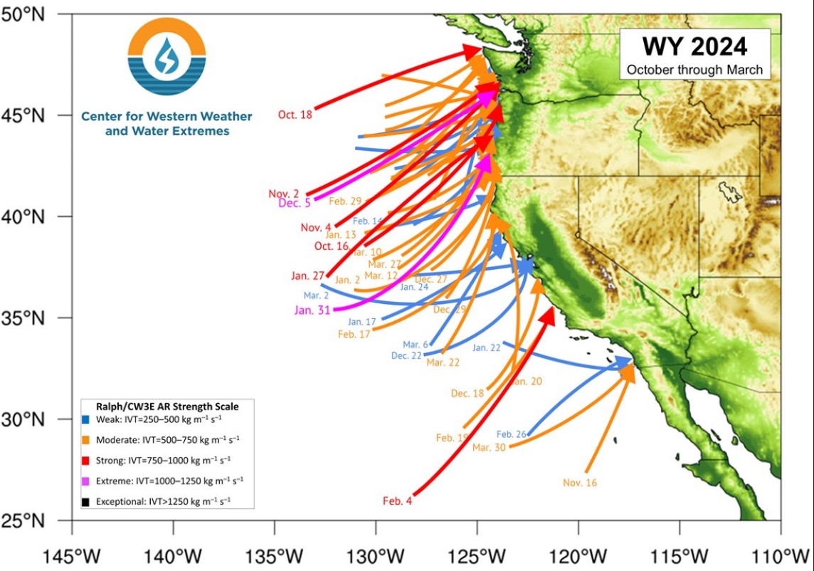
The Center for Western Weather and Water Extremes says the West Coast experienced 51 atmospheric river (AR) events between 10/2023 – 3/2024.

ENSO Forecast
We’re currently on La Nina Watch. El Nino is fading and we’re headed into a Neutral Phase and then quickly into La Nina by June 2024. La Nina looks to persist into Winter 2024-2025.
Below is the European Model forecast for sea surface temps in the South Pacific near the Equator (NINO 3.4 zone). The red lines move towards colder water temps (La Nina).

May 2024 Forecast
The ECMWF suggests the pattern below. Green represents above normal precipitation, and brown/tan represents below normal precipitation.

Monsoon Forecast
La Nina normally tilts the odds in favor a wetter than normal Summer (July-August) Monsoon Season across the West.

Vail is currently at 291” (snowfall) which means we’ll end up 15% below average vs the Upper Colorado River Basin at 7% ABOVE average. Can you explain the discrepancy? Quite honestly, while the SWE is great to see, it wasn’t that great of a ski season
The winter in Vail was odd in that we had several BIG snows followed by weeks of really warm temps. We are normally smaller but more frequent storms. The warmth is just the Nino, always works that way.
Thanks, Matt! Another Winter in the books. Chris
Thanks, Steve! Vail Ski Area values are different than NRCS SNOTEL values. NRCS has Vail Mountain (10,310′) at 105% (19.2″ SWE) of median. Chris
Thanks for all the blogs this winter! Great information that our family and friends used at home and at work!
Thanks, Cathy P! Chris
Tomer! Thanks for the great weather info again, this season! Now I can’t wait until July when (hopefully) you do your forecast for the High Lonesome 100! Thanks again!
Thanks, Mitch! I’ll put the High Lonesome on my list again. Chris
Cheers from Red Mountain in Rossland BC ! Thanks for including us in your forecasting ! RT
You bet, thanks, Rick! Chris
Great stuff Chris, I follow religiously! Enjoy your forecasts as an amateur meteorologist myself!
Thanks!
Thanks, Justin! Chris
Check your forecast every day. Spot on and helpful with ski trip planning and drives across CO.
Thanks, Dave! Chris
Thank you for all of the forecasts this Winter Chris! I always enjoyed reading them, they were helpful, and I appreciate your work.
Thanks so much, Ellen! Appreciate you stopping by. Chris
Thanks Chris, avid listener / reader here. Greatly appreciate the content. Nice to have a wetter than average snowfall year in the northern Sangres / upper ark river basin. Thanks!
Thanks, Hunter! Chris
Chris,
with a La Nina starting in June, what does that mean for those of us climbing on Denali that month?
Hi Jennifer, to my knowledge there is not discernable pattern for the ‘warm’ months, June-August. Chris
I think it was a pretty good year for winter sports.. Chris, thank you for your forecasts and your teaching me of looking at water vapor maps (I use the animated https://weather.ndc.nasa.gov/goes/abi/goesWestfullDiskband08.html to salivate over in between your postings)
We really knew what to expect when we went from Whistler to Banff, Kirkwood and Palisades, even just last week the Colorado low came through and on a pre-planned trip we were able to squeeze the last of Taos… one more day trip to Tahoe this weekend and we can call it a season!
I really appreciate what you do and how you do it!
…Is Argentina/Chile setting up this summer? ⛷️
Thanks so much, David! Appreciate the comments. What location in Argentina/Chile are you interested in? Chris
We were dreaming about Valley nevado, chile or las lenas, Argentina… it was father-son chat on the lift one day.. (I’ve been lucky enough to have 2 sons who love winter sports.. and committed to epic and ikon..).
This year, is La Niña bringing storms down the gulf of Alaska and through PAC NW with little/no influence from Hawaii souther branch? Less chances for the types of AR’s that went through California this year? To me cooling oceans would increase wind speeds so the storms would be shorter, maybe stronger than this year’s El Niño where the southern and northern branches met so many times and elongated the storms..
I’ll be tuned in next year. Best regards,
David
first timer to your blog and I found it incredibly helpful as we skied Whistler for the first time. Will be checking your forecast next season!!
Chris,
Thanks for your forecasts this season. You are one of my favorite forecasters for the Wasatch and I’m happy that you have gone into such strong detail for the Wasatch and surrounding areas.
Happy summer!