GOES-17 high resolution visible satellite captured the Hunga Tonga volcano blowing its top. How high did it shoot? Professor John Peters suggests it might’ve reached the Stratospheric canopy. That’s over 100,000 feet or higher into the vertical atmosphere.
GOES-17 high resolution visible satellite.
Here’s the Infrared channel from GOES-17. Notice the shockwaves –>
GOES-17 Infrared satellite.
The magnitude of the eruption is being called a once-in-a-decade-event. It was so powerful it sent atmospheric shockwaves around the world.
There was more than one atmospheric shockwave. I’ve seen evidence of three separate waves, at different magnitudes, at different times, and traveling at different directions like waves in a pond.
Here’s one shockwave timelapse courtesy Daryl Herzmann.
ASOS atmospheric pressure perturbations, data via NCEI/NWS.
Primary storm track favors the Northeast with numerous storm systems, Alberta Clippers, lake effect, and cold temperatures.
Western high pressure remains in place with occasional cold fronts sneaking through the periphery running through ID, MT, WY, CO and UT. This is in-line with a peaking La Nina pattern.
When will a larger pattern change hit the Intermountain West? Potentially around 2/1 when the Pacific North American (PNA) oscillation turns negative (see forecast below).
Infrared satellite shows the storm track with Western ridge and Eastern trough. Occasional cold fronts will sneak through the periphery of the Western ridge next two weeks.
Infrared satellite with storm track 1/17/2022 5am.
Snow & Blowing
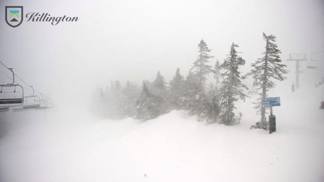
Mount Washington recorded a 121mph wind gust Monday morning. It’s snowing and blowing at Okemo and Killington, VT.
Killington, VT 1/17/2022 9am.
Take a look at this video of a chair at Okemo blowing wildly!
Okemo, VT 1/17/2022.
Fronts Sneak Through
One of those cold fronts races through WY, MT, ID, UT, and CO this Thursday night-Friday (1/21). Notice the dip in the jet stream.
We could see a similar cold front on 1/24-1/25 race through MT, WY, ID, UT, and CO.
This pattern is in-line with a peaking La Nina pattern.
ENSO 2020-2021-2022.
La Nina forecast:
Looking Down the Road
When will the Intermountain West see a larger pattern change? Potentially around 2/1. The Pacific North American (PNA) pattern turns negative towards the end of January. Negative PNA stacks the odds in favor of colder/stormier for the West.
Pacific North American Pattern (PNA) Ensemble forecast, 1/17/2022.
This agrees with the forecast pressure pattern around 2/1.
The West is largely dominated by high pressure. A few small cold fronts will sneak through the eastern periphery through 1/23 with minor snow accumulation in MT, WY, UT, and CO.
Ski the Northeast this Sunday-Monday with a Nor` Easter on tap.
When will this pattern change for the Intermountain West? It could be a long wait and confidence is low. Potentially by 1/29 or later.
Infrared satellite shows the storm track and lack of activity across most of the West.
Infrared satellite and storm track 1/14/2022 5am.
Looking down the road
A few small cold fronts will sneak through the eastern periphery of the Western high pressure. But, a larger pattern change could be a long way off. Below is one possible scenario around 1/29 with lower pressures building across the Intermountain West.
I talked with Dale Atkins of Alpine Rescue Team about how this technology works and how it will be used. Atkins has been involved in avalanche rescues since the 1970s.
Notice the beacon hanging from the bottom of the helicopter. Photo Dale Atkins on 1/10.
Efficiency
Search and Rescue (SAR) is a two-part operation and involves several agencies. First, you must locate the missing the person(s) before any rescue can be performed. Atkins said, “This is another tool in our toolbox. The helicopter can cover great distances in a short amount of time.” Atkins stressed to me that this technology can’t be used for all SAR missions, but when deployed it will likely increase SAR efficiency.
Search and Rescue involves several agencies. Photo Dale Atkins on 1/10.
Limitations
Weather, type of emergency call, location of emergency, and size of avalanche are all considered before Flight for Life is deployed.
“I could see using this technology for very large avalanches with numerous missing people. It could be used just outside of ski area boundaries. I could see using this technology in remote locations with numerous small avalanches that would normally take ground crews a long time to search,” Atkins said.
Demonstrating the new (to CO) beacon technology with responding agencies. Photo John Kyler, CCSO, on 1/10.
Colorado Avalanche Risk
Colorado leads the United States in avalanche deaths per year. In between storm cycles, we see numerous sunny, dry days dominated by high pressure. These frequent changes in temperature and humidity create rotten snow layers (snow faceting).
Atkins also says we have a large population with easy access to high risk terrain.
As we wrapped up our chat, Atkins said staying safe in the backcountry is largely about terrain selection. “Know where you’re going. How steep is it? Are there signs of other avalanches? How stable is the snowpack? Get educated before buying any gear.”
Ethan Greene (CAIC) and Dale Atkins. Photo John Kyler, CCSO, on 1/10.Search mode. Photo John Kyler, CCSO, on 1/10.
A cold front sneaks through the eastern periphery of this Western high pressure on Friday 1/14.
This fast-moving cold front delivers light snow accumulation to Montana, Wyoming, and Colorado on Friday 1/14. Then it’s back to dry weather for a week.
The most active weather occurs in British Columbia and at times WA.
When will a larger pattern change occur for the Intermountain West? Data is mixed and confidence is low. There are signs of a stronger cold front around the 22nd or later, but even this could be optimistic.
The infrared satellite shows the storm track. The jet stream remains most active in British Columbia and at times WA.
Infrared satellite and storm track, 1/13/2022 5am.
Longer Range
Looking down the road, a stronger cold front might brush the Intermountain West around 1/22 or later.
Pressure anomalies valid 1/22/2022, Euro interpretation.
Snow Forecast
A minor, fast-moving cold front hits MT, WY, and CO on 1/14 then it turns dry until 1/22-ish.
1/13-1/18:
Inches of total snow 1/13-1/18.
1/19-1/22:
The snow you see in MT, WY, and CO occurs on/around 1/22.
My good friend Ryan Kushner sent me this outstanding sunrise video from Monday morning on the 14,265′ summit of Quandary Peak, CO.
I’ve climbed mountains with Ryan for 16 years. He’s climbed all over the world including G2, Dhaulagiri, Manaslu, Denali, and South America. I’m sure Ryan has something big planned soon!
Quandary Peak summit sunrise 1/11/2022, Ryan Kushner.
Tomer’s Take
A rather tranquil period through 1/16.
One minor cold front delivers light snow accumulation to MT, WY, CO, and NM between 1/13-1/14.
When will this pattern change? Data is mixed. Lower pressures might brush UT, MT, WY, and CO around 1/20-1/22.
It’s really a waiting game until we break the high pressure dome across the West.
Infrared satellite and storm track. Notice the big high pressure dome across the West.
Infrared satellite and storm track, 1/12/2022 5am.
Waiting Game
There’s some indication that slightly lower pressures might brush the Intermountain West 1/20-1/22.
Reversal of fortune for the West after a 2-4 week solid storm cycle.
Splitting jet stream and high pressure builds in through 1/18 with only minor fronts.
Warmer and drier than normal in CA, UT, WY, CO, NM.
Potential break in the pattern by 1/19 or later.
The best snow with an active jet stream remains in the Pacific Northwest, British Columbia, and western Alberta.
Infrared satellite shows the splitting jet stream and large high pressure dome across the West.
Infrared satellite 1/10/2022 5am.
When will the pattern change?
Looking down the road, high pressure dominates through 1/18 with only minor fronts for the Intermountain West. A potential change occurs around 1/19 or later as pressures drop.
My snow forecast through 1/19 is abnormally dry for the lower 48 and Intermountain West. The 1-2″ you see in Colorado occurs with a minor front on 1/14.