Tomer’s Take: Two different storm systems remain on track 2/1-2/8. Storm #1 (2/1-2/4) delivers a moderate intensity atmospheric river (AR) surge, widespread heavy interior Rockies snow accumulation, and a Panhandle Hooker storm system for Colorado on 2/3. Storm #2 (2/5-2/8) delivers a weak AR surge and moderate to heavy interior Rockies snow accumulation.
My afternoon forecast video update:
Old Man Winter Rally 2/4
Event takes place in Lyons, CO on 2/4.
2/2: Increasing clouds, Rain to snow after 10pm, gusts under 15mph, 34/40F.
2/3: 3-6 inches, gusts under 15mph, 32/34F.
2/4: Drier, cloudy, 29/38F.
Current Setup
Water vapor satellite shows both storm systems lined-up in the Pacific riding a powerful Subtropical jet stream.
Orange/red = drier air aloft.

Forecast Freezing Level
Forecast rain/snow line (daily min/max):
Sierra, CA:
1/31: Falling from 10,000′ to 7,400′.
2/1: Falling from 7000′ to 3600′.
2/2: 2300/5600′.
2/3: 5100/6200′.
2/4: 5600/7200′.
Wasatch, UT:
2/1: 7900/9400′.
2/2: 5600/7100′.
2/3: 3900/5200′.
2/4: 5900/6700′.
Forecast Atmospheric River
Forecast Integrated Vapor Transport (IVT) showing two AR surges.

Forecast Jet Stream
Storm #1 arrives with powerful Subtropical jet stream.

Storm #2. Notice the trough moving west to east through UT/AZ/NM/CO.

Forecast Radar & Satellite
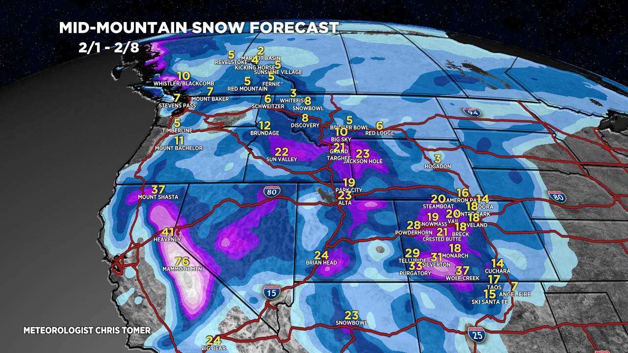
Forecast Totals

Grand Totals: Storm #1 + Storm #2.

Storm #1.

Storm #2.


Thanks Chris!
Do you accept gifts for such forecasts?
Paul in Silverthorne
Thanks, Paul! Always accept gifts ;-D Chris