Tomer’s Take: A major pattern shift hits the West 1/5-1/12. It’s comprised of a 2-3 storm cycle with colder temps and heavy snow accumulation. Before it arrives, a southern track storm system departs CA and slides through UT/AZ/NM/CO 1/3-1/5 with light to moderate snow accumulation. In addition, a vanguard area of light snow races through ID/MT/WY/UT/CO on 1/5.
In the Northeast, moderate to heavy snow accumulation is likely 1/6-1/7. If this stormtrack wobbles north then snow totals increase in VT/NH/ME. A 2nd powerful storm system arrives 1/9-1/10 with 70mph gusts and heavy snow changing to a rain/snow mix.
My afternoon forecast video update:
Current Setup
Water vapor satellite shows the southern track storm system departing CA, and the powerful pattern changing area of low pressure in the north Pacific.
Orange/red = drier air aloft.

Forecast Jet Stream
Pattern changing low diving south from AK/Canada into PNW. Vanguard snow races through Intermountain West 1/5.

Deep trough slides through Intermountain West.

2nd storm system with broad trough traverses the West with cold and snow. A 3rd storm might arrive after.

Forecast Radar & Satellite
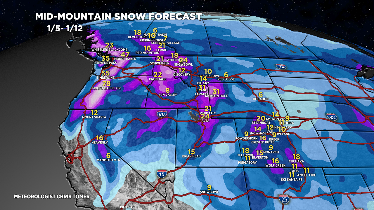
Forecast Totals

Grand totals from 2-3 separate storm systems. Doesn’t all accumulate at one time.

*Updated 4:30pm 1/3.
These totals include both 1/6/-1/7 storm system and 1/9-1/10 storm system. 1/6-1/7 stormtrack has wobbled back north a touch increasing these totals. 1/9-1/10 is a powerhouse with 70mph gusts and heavy snow possibly changing to a rain/snow mix.

Let’s goooo ❄️🤩
Thanks, Sean…finally some snow and cold!