Tomer’s Take: Grand totals are trending up in UT, CA, and CO with two different storm systems 2/1-2/9. I’m forecasting three grand total bullseyes in the Sierra, Wasatch, and Southwest CO. Both storm systems deliver a moderate intensity surge of Atmospheric River (AR) moisture to CA. Storm #1 hits now through 2/4, and storm #2 hits 2/5-2/9. On 2/3, a Panhandle Hooker storm system develops around the TX/OK Panhandle and forces snow (or rain/snow) development in Denver, Foothills, and Mountains. The intensity and track of this storm system dictates how much accumulation occurs at Loveland, A-Basin, Summit County, Winter Park, Keystone, and Eldora.
My afternoon forecast video update:
Old Man Winter Rally 2/4
Event takes place in Lyons, CO on 2/4.
2/2: Increasing clouds, gusts under 15mph, 35/44F.
2/3: 3-6 inches (mixing with rain), gusts under 15mph, 33/39F.
2/4: 1 inch snow until 9am then drier, wind gusts under 15mph, 32/37F.
Current Setup
Water vapor satellite shows both storm systems lined-up and escorted by a strong Subtropical jet.
Orange/red = drier air aloft.

Central/Northern CA radar shows heavy precipitation inbound. Snow hits Tahoe and Mammoth tonight into 2/1 above 7,000ft.

Forecast Atmospheric River
Forecast Integrated Vapor Transport (IVT) for the Central/Northern CA Coast at 38N/123W. Notice two moderate intensity AR surges.

Forecast Jet Stream
Storm #1 riding strong Subtropical jet 2/1-2/4.

Storm #2 with broad trough 2/5-2/9.

Forecast Radar & Satellite
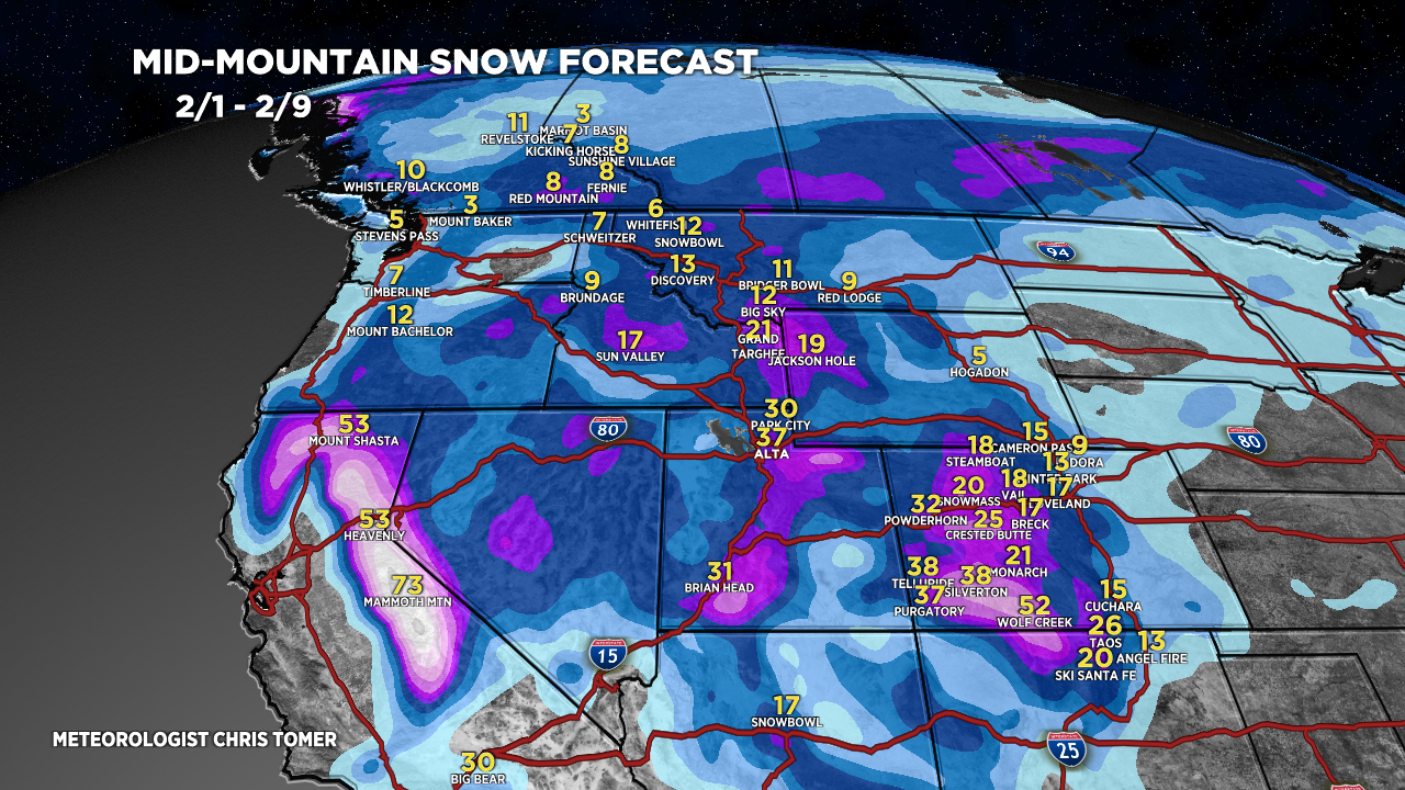
Forecast Totals
Grand Totals: Storm #1 + Storm #2.
Totals are trending up in the Wasatch, CA, and CO.
Three bullseyes: Sierra, Wasatch, Southwest Colorado.

Storm #1.

Storm #2.

