Tomer’s Take: Snow accumulation over the last 24hours is bonus snow – appetizer snow. There are three different storm systems lined-up with this storm cycle through 1/15. Storm #1 arrives today through 1/8. Storm #2 1/9-1/11. Storm #3 1/12-1/15. Confidence is lowest in storm #3 as guidance shifts dramatically with respect to Arctic air and storm strength.
All three storm systems hit the Northeast through 1/15. Storm #1 occurs 1/6-1/7 with moderate to heavy snow accumulation. Storm #2 1/9-1/10 is a powerhouse with 70mph wind gusts, heavy snow at the onset changing to rain or a rain/snow mix at the big resorts. Storm #3 1/13 continues to evolve with moderate to heavy snow potential.
My afternoon forecast video update:
Steamboat got nailed over the last 24 hours. 14″ in 24 hours and 19″ in 48 hours. And, it’s still snowing. This is bonus snow.

Current Setup
Water vapor satellite shows storm #1 and storm #2 lined-up. Storm #1 is the pattern changer.
In the Northeast, notice the area of low pressure gathering steam.
Orange/red = drier air aloft.

Forecast Jet Stream
Storm #1, deep trough.

Storm #2, broad, deep trough.

Storm #3, trough, colder air.

Forecast Radar & Satellite
Forecast Totals
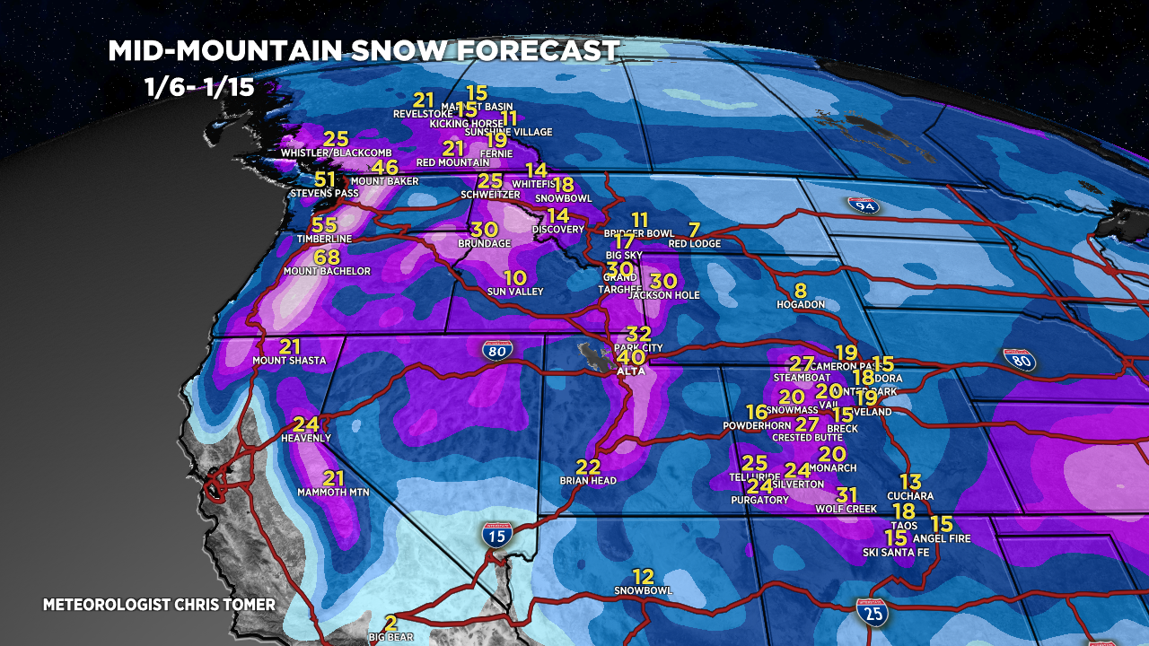
Grand Totals 1/6-1/15. Storm #1+#2+#3.

Storm #1.

Storm #2.

Storm #3.

Grand Totals 1/6-1/15.
VT/NH/ME Snow: 1/6-1/7, 1/9-1/10 (Wind/Snow/Rain), 1/13.
