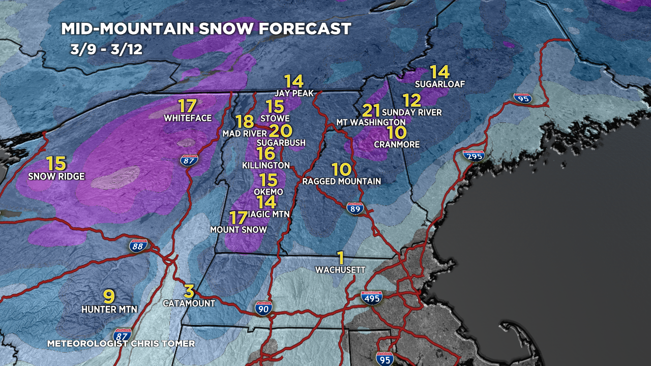
Tomer’s Take: Heavy snow hits the major ski areas of NY/VT/NH/ME the evening of 3/9 through 3/10. Light snow trickles into early 3/11. Out West, the pattern favors the PNW/BC/Northern Tier 3/9-3/11 for moderate to heavy snow accumulation. This pattern and a storm system dives south into ID/WY/UT/CO/NM 3/12-3/14 with moderate to heavy snow accumulation. The storm systems strengthens in CO/NM with snowfall enhancement.
Timing
*Updated 4pm 3/9/2024.
Northeast: Heavy Snow Tonight-3/10 (above 1500ft), M/H 3/15-3/16. Tetons: M/H 3/12-3/13.
Wasatch: Light Snow PM 3/11, M/H 3/12-3/13.
Colorado: M/H Snow Late 3/12-3/15.
Revelstoke: Heavy Snow Late 3/9-3/12.
My afternoon forecast video update:
Current Setup
Water vapor satellite shows a loaded Northern Branch targeting the PNW/BC/Northern Tier through 3/11. Also notice the storm system sliding into the Northeast with the Southern Jet.
Orange/red = drier air aloft.

Forecast Radar & Satellite
Forecast Totals
Grand totals by late 3/18.


Really appreciate your regular updates. Very helpful on a pass like Mountain Collective. When do you expect the next major snow event for the intermountain west after the 18th?
Thanks, Tim! High pressure appears to build after 16th through at least the 19th – maybe longer. Chris
thanks. heavy means accumulation not wetness, correct?
Hi Kevin, correct “heavy” refers to heavy accumulation 10 inches or more. Chris