Tomer’s Take: A powerful storm cycle continues with storm systems on both coasts through 1/17. Out West, a blizzard (storm #2) hammers OR/WA 1/9. This storm system then moves into the Interior Rockies 1/9-1/11. Storm #3 delivers an Arctic front 1/12-1/15. Another storm system hits the PNW then Interior Rockies 1/16-1/17.
In the Northeast, each of these storm systems develop into major areas of low pressure. A bomb cyclone arrives 1/9-1/10 with 70mph gusts and heavy snow changing to rain/snow or rain at the VT/NH/ME ski areas. Another storm system arrives 1/12-1/13 with 70mph gusts and heavy snow changing to a rain/snow mix. A third storm system hits with heavy snow 1/16-1/17.
My afternoon forecast video update:
Snow Timing Cheat Sheet
Wasatch: PM 1/9-1/10, PM 1/11-1/14, 1/17-1/18.
Tetons: 1/9- AM 1/12, 1/13, 1/16-1/18.
Idaho: 1/9-1/11, 1/15-1/18.
WA/OR: 1/9-1/13, 1/16-1/18.
CO: 1/10-1/14, 1/17-1/18.
Current Setup
The Pacific is a busy place with a few different areas of low pressure riding both the northern and southern jet branches.
Orange/red = drier air aloft.

A powerhouse storm system (bomb cyclone) develops in the Midwest then hits the Northeast 1/9-1/10.

Forecast Jet Stream
Storm #2 dropping into the Interior Rockies.

Storm #3 + Arctic Front.

Storm #4 hits PNW then slides into the Interior Rockies.

Forecast Radar & Satellite
Forecast Wind Gusts
Mount Bachelor, OR:
1/9: 65mph
1/10: 50mph
1/11: 60-65mph
1/12: 50mph
1/17: 65mph
Mount Superior, UT:
1/12: 55mph
Vail Mountain, CO:
1/10: 50mph
1/12: 60mph
1/13: 45mph
Longs Peak, CO:
1/9 & 1/10: 60mph
1/12 & 1/13: 55-60mph
1/16 & 1/17: 60-65mph
Quandary Peak, CO
1/9-1/10: 50mph
1/12 & 1/13: 65mph
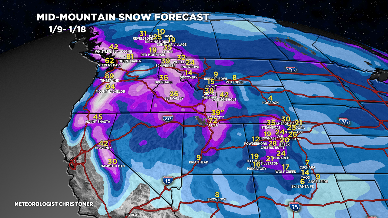
Forecast Totals
Grand Totals by 1/18.

Storm #2.

Storm #3.

Storm #4.

