Tomer’s Take: Today is transition day with a storm system hand-off. Snow continues 1/11 in CO/NM diminishing from north to south. Then snow redevelops WA/OR/MT/ID/WY/CO on 1/12 as an Arctic front barrels south. Air temps run 30 to 50 degrees below normal. A storm system rides this Arctic front with strong orographics, high snow ratios, and a jet blast. 40-70mph wind gusts likely in UT/WY/CO on 1/12-1/13 raking the high peaks. Another storm system hits BC/MT/ID/WY/UT/CO 1/16-1/19 with a NW flow orientation.
In the Northeast, a strong storm system arrives 1/12-1/13 with 70mph gusts and heavy snow changing to rain/snow VT/NH/ME. What once looked like a promising snowstorm on 1/16-1/17 is tracking even further south now with less accumulation in VH/NH/ME. Another storm system arrives 1/19-1/20 with heavy snow potential.
My afternoon forecast video update:
Heavy snow continues today at Aspen/Snowmass with 4-8 inches of accumulation.

Snowbasin, UT is reporting 12″ in 24 hours. I’m forecasting another 1-2 feet across the Wasatch 1/10-1/11.

Forecast Jet Stream
Arctic front and powerful jet merger.

Main storm system moving through UT/CO/NM.

Storm system 1/16-1/19 and NW flow orientation.

Forecast Wind Gusts
Forecast Wind Gusts in Colorado on 1/12 at 2pm. Similar gusts early 1/13.

Mount Superior, UT:
1/12: 70mph.
1/13: AM 60mph, PM 50mph.
Grand Teton, WY:
1/12: 70mph.
1/13: AM 50mph, PM 40mph.
Forecast Radar & Satellite
Special Advisory
From the Colorado Avalanche Information Center pertaining to this weekend:

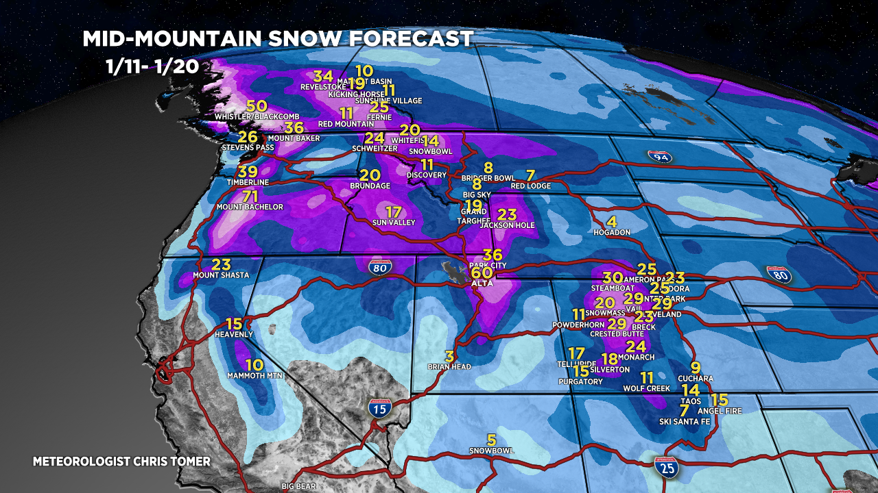
Forecast Totals
Totals by late 1/20.

Arctic front + next storm system 1/12-1/15.

Strong orographics, high snow ratios, and jet blast.

Storm system + NW Flow orientation.

Northeast:
*Updated 4pm 1/11.
Only storm on the horizon is 1/12-1/13.
