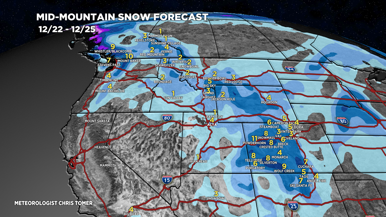
Tomer’s Take: The Christmas Eve storm system looks about the same as yesterday. A weak merger (of two areas of low pressure) generates light snow accumulation in the Wasatch and Tetons. Moderate to heavy accumulation in Southern Wyoming and parts of Colorado.
A couple different storm systems and rich flow impact the Sierra 12/27-12/30.
That storm system exits CA and moves through UT/MT/ID/WY/CO on/around New Year’s Eve.
My afternoon forecast video:
Current Setup
Water vapor satellite shows the two areas of low pressure that eventually merge over WY/CO. The third low hits the PNW/BC with heavy precip.
Orange/red = drier air aloft.

Forecast Jet Stream
Trough quickly exiting WY/CO.

Trough and strong jet ushering moisture into the West Coast/PNW/CA.

Forecast Radar & Satellite
New Years Eve Forecast
A storm system slides through the Intermountain West with light snow accumulation.

Forecast Totals
*Updated 2:30pm 12/22.
UT Snow: 12/23.
Teton Snow: 12/23.
CO Snow: 12/23-12/24.

*Updated 2:30pm 12/22.
CA Snow: 12/27, 12/29-12/30.

*Updated 2:30pm 12/22.
NY/VT/NH/ME Precip: 12/27-12/29.

Thanks for doing these, they’re awesome. Any chance you could add kicking horse to the snow totals map? It’s in kind of an awkward spot right between Banff and Revelstoke on the edge of a huge valley right next to the continental divide, and the forecast never seems to get it quite right for them.
I’m also wondering what models you use to make your forecasts? Do you ever check the HRDPS?
Thanks
Thanks, Brett. I’ll put Kicking Horse on my to-do list. I use different models for different regions and synoptic setups. Chris
Happy Holidays, Chris
Thanks, Judi! Same to you and family. Chris