Tomer’s Take: Snow continues today in WY, UT, and CO. Saturday is dry. Additional snow hits the Tetons and Colorado on Sunday and Monday.
In the Northeast, a windy storm system hits 12/10-12/11 with rain initially then changing over to snow on 12/11.
About 7 inches in 24 hours at Winter Park, CO with a 2nd wave of snow this afternoon. Additional light snow hits PM 12/10.

7 inches in 24 hours at Aspen & Snowmass with a 2nd wave this afternoon.

13 inches in the last 24 hours at Alta, UT and still snowing.

Current Setup
Water vapor satellite shows the storm system moving through UT, WY, CO. It’s next stop is the Northeast.
Additional areas of low pressure across the Pacific will deliver snow to the Northern Tier of states.

Forecast Jet Stream
Valid 12/8. Trough over WY/UT/CO delivering snow. This storm system becomes the large East Coast storm system 12/10-12/11.

Valid 12/10. Fast, progressive jet flow favoring Northern Tier for additional snow accumulation.

Valid 12/17. Slight dip over West Coast might bring snow back to CA.

Forecast Radar & Satellite
Eastern Storm System
Valid 12/10. Powerful jet generating a storm system and strong wind. Pushes warm air and rain initially into VT/NH/ME.

Valid 12/10 9pm. Forecast radar & satellite.

Forecast Totals
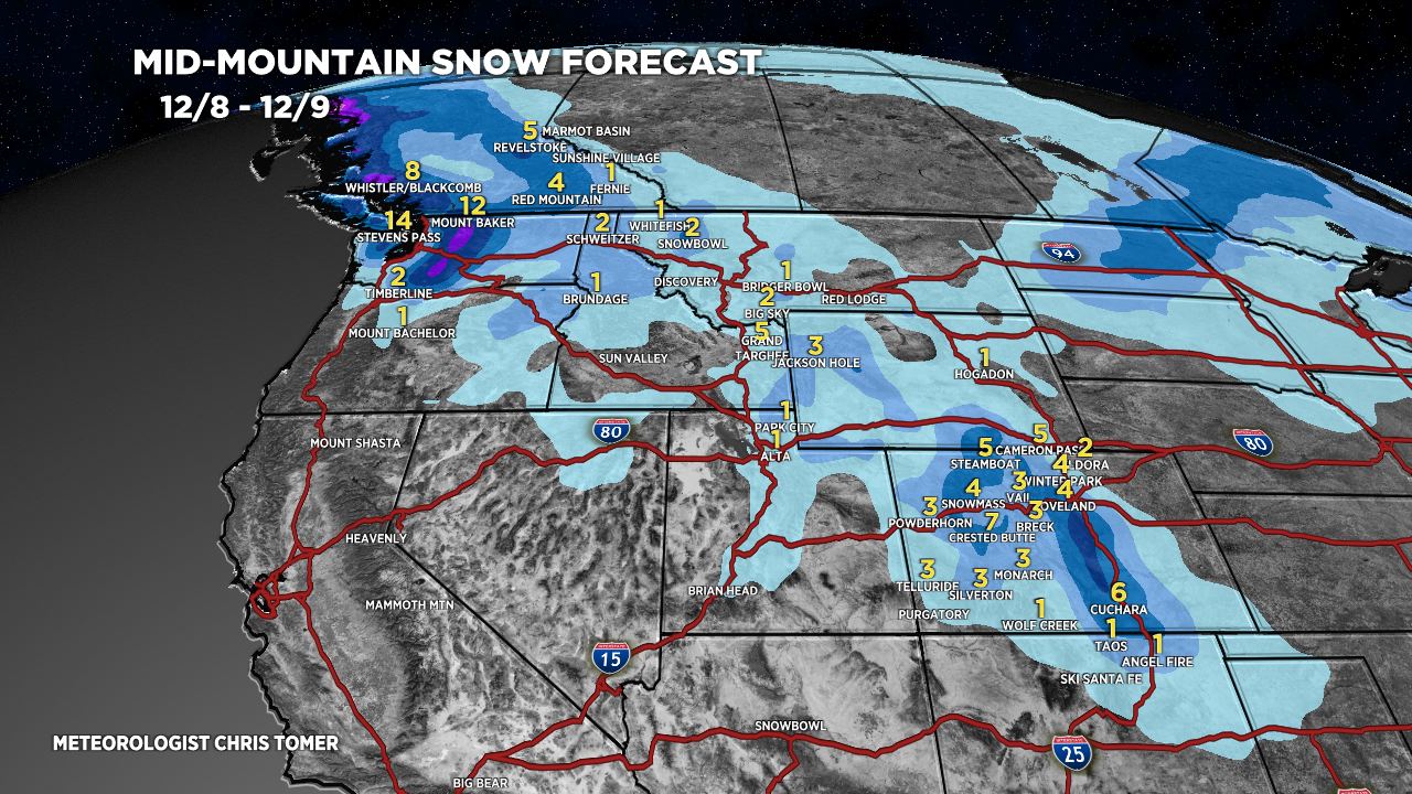
*Updated 2pm 12/8.
Additional snow accumulation 12/8-12/9.

*Updated 2pm 12/8.
CO Snow: 12/10 (light), 12/10-12/11 (light), 12/12-12/13 (light).
WY Snow: 12/10-12/11 (moderate).

*Updated 2pm 12/8.

*Updated 2pm 12/8.
Rain 12/10 changing to snow 12/11.
