Tomer’s Take: Snow is falling across the Wasatch today then Colorado gets light to moderate accumulation 11/8-11/9. A much more significant pattern shift occurs on/after 11/13. A deep trough starts in the PNW/BC then digs south through CA with impressive snow totals and colder air. An atmospheric river (AR) component is also possible along with Subtropical Jet involvement. Snow from this setup would likely spread throughout the interior West including UT, CO, and WY.
My forecast video 4:45pm 11/7:
3-6 inches of snow is likely in Big and Little Cottonwood Canyons, UT with a glancing blow from a cold front.
It’s currently snowing at Alta:

Current Setup
Water vapor satellite shows an active jet pattern running off the North Pacific.

Forecast Jet Stream
Valid 11/14. Deep trough digging south from PNW into CA with big totals possible.

Valid 11/16. Jet flattens and becomes moisture conveyor-belt for interior Rockies.

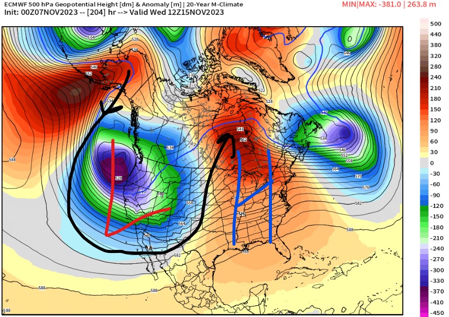
Valid 11/15. Forecast mid-tropospheric atmospheric pressure anomalies show a deep area of low pressure off the West Coast. Anomalies run three standard deviations below the 30-year normal.

Forecast Atmospheric River
Valid next 10 days at 38N/123W (near San Francisco), Integrated Vapor Transport (ITV). Notice the sharp uptick in forecast moisture on/after 11/13.

Forecast Radar & Satellite
Forecast Totals
*Updated 2:45pm 11/7.
Valid 11/7-11/10 mid-mountain. Colorado’s snow occurs 11/8-11/9.

*Updated 2:45pm 11/7.
Valid 11/11-16 mid-mountain. The bulk of this snow occurs on/after 11/13.
