Tomer’s Take: The next storm system departs the PNW and hits ID, MT, WY, UT, and CO 12/7-12/9. This same storm system develops into a strong, windy East Coast storm system with rain on 12/10 and then snow 12/11.
7″ in 24 hours at Big Sky and snow continues to fall plus 30-50mph wind gusts. Additional snow is likely on 12/8, 12/10-12/11.

It’s snowing hard at Alta, UT with a break tonight then snow returns on 12/8.

Current Setup
Water vapor satellite shows two storm systems over the Pacific. Both hit the PNW and then Intermountain West. The 1st storm system is major, and the 2nd is minor.
Orange/red = drier air aloft.

Forecast Jet Stream
Valid 12/8. Notice the trough over WY, CO supporting an area of low pressure and snow accumulation.

Valid 12/16. Possible area of low pressure pulling out of Southern CO and Northern NM.

East Coast Storm System
Valid 12/10. Powerful jet stream and lots of wind. This setup puts the ski resorts of VT/NH/ME in the warm sector and mostly rain on 12/10 then changing to snow early 12/11.

Valid 12/10. Forecast radar shows all wind and rain for VT/NH/ME. Changes to snow on 12/11.

Forecast Radar & Satellite
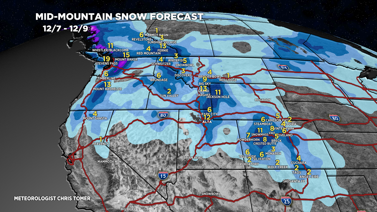
Forecast Totals
WY Snow: 12/7-12/8 (Heavy), 12/10-12/11 (Light).
CO Snow: Late 12/7-12/8 (Moderate), 12/14-12/15 (Light).
UT Snow: 12/7-12/8 (Moderate to Heavy).


Rain changes to snow around 5am on 12/11 in VT.

El Nino Update
Latest forecast guidance suggest a rapid and sharp transition from a strong El Nino to La Nina during Spring 2024 into Summer 2024.
Below is the ECMWF ensemble for ENSO region 3.4 next 10 months.
It’s a sharp turn after JAN/FEB 2024. This is one reason why an El Nino Modoki is possible JAN/FEB/MAR during the transition.

Chris, can you remind us what el nino modoki means for California and the Intermountain West, versus a more traditional el nino pattern?
Should we expect more snow, or perhaps a drier year?
Thanks for all the awesome updates, no one does it better!
Thanks, Liam!
Modoki is part of the transition process from El Nino in this case to Neutral then La Nina. It’s happening late in the Winter so the impact might only be 30-40% on the overall pattern.
If you’re not doing well with a strong El Nino, then a shifting pattern (Modoki) might change your situation. In California, lets see what late December, JAN and FEB deliver before Modoki arrives MAR/APR.
Chris