Tomer’s Take: Monsoon Season normally runs July-August across the Rockies. I’m forecasting a late start. Data suggest it might not start until after 7/10. A large dome of high pressure is currently blocking the flow. But, even without Monsoon moisture, afternoon thunderstorms are still possible over higher terrain from daytime heating and fronts racing through. Wetter than normal conditions remain likely for WY, MT, ID, and NE CO through 7/11 with an active jet stream.
What is the Seasonal Monsoon? It’s extra moisture from the Gulf and Pacific that streams into the West making afternoon thunderstorms more likely with frequent lightning, flash flooding, gusty wind, and hail.
El Nino Contribution: Data suggest that El Nino can disrupt and weaken the North American Monsoon.
Current Pattern – Monsoon Blocked
Red/orange = drier air. A dome of high pressure over Mexico is blocking the moisture flow. Normally, winds turn southerly and escort rich moisture into the United States. How long will this high pressure last? At least until 7/10. But, notice the jet stream flow running west to east across the West. This will deliver several fronts to the Rockies and keep afternoon thunderstorms going.
Valid 7am 6/27/2023:

Forecast Pattern
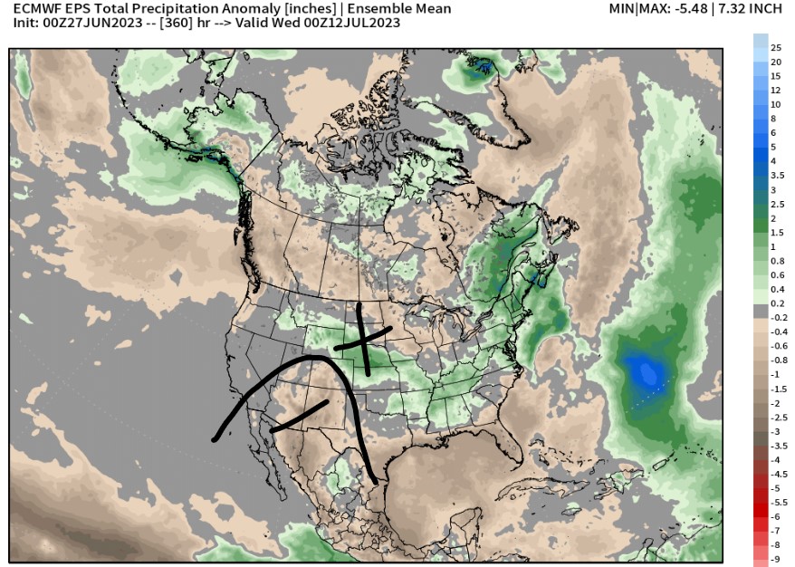
Valid: 6/27 – 7/11
Drier than normal precip anomalies remain in place through 7/11 for NM, AZ, SW CO, UT. Wetter than normal precip anomalies for WY, MT, ID, NE CO with strong jet flow.

Valid: 7/7
Notice the abnormally strong Subtropical Jet running west to east from the Pacific to CA, NV, UT, CO. This will keep the Monsoon suppressed. WY, MT, ID, NE CO stay wetter than normal if this plays out.

High Peaks Forecast
Longs Peak, CO
6/30: Front, AM dry, PM 80% t-storm/rain/snow, 15-25mph gusts.
7/1: AM dry, PM 20% t-storm, 15-20mph.
7/2: AM dry, PM 40% t-storm, 15-30mph.
7/3: AM dry, PM 20% t-storm, 15-30mph.
7/4: AM dry, PM 40% t-storm,15-30mph.
Mount Sneffels, CO
6/30: AM dry, PM 20% t-storm, 15-30mph gusts.
7/1: Dry, sun, 15-25mph.
7/2: AM dry, PM 10% t-storm, 15-35mph.
7/3: AM dry, PM 20% t-storm, 15-35mph.
7/4: AM dry, PM 20% t-storm, 15-35mph.
Grand Teton, WY
6/27-6/29: Unsettled, PM t-storm/rain/snow.
6/30: Dry, sun, 10-20mph gusts.
7/1: Dry, 10-20mph.
7/2: Dry, 15-35mph.
7/3: AM dry, PM 20%, 15-35mph.
7/4: AM dry, PM 20%, 15-35mph.
Mount Superior, UT
6/30: AM dry, PM 30% t-storm, 15-30mph gusts.
7/1: Dry, sun, 15-25mph.
7/2: AM dry, PM 10% t-storm, 15-35mph.
7/3: AM dry, PM 10% t-storm, 15-25mph.
7/4: AM dry, PM 30% t-storm, 10-25mph.
Mount Rainier, WA
6/30: Dry, sun, 20-35mph gusts.
7/1: Dry, sun, 25-35mph.
7/2: Dry, 20-30mph.
7/3: Dry, 15-25mph.
7/4: Dry, 15-25mph.
Wondering why that west-to-east flow straight across CO leads to dry weather on the western slope (especially considering how productive that pattern can be in the cold season). Is there just no moisture for it to interact with until it gets onto the eastern plains? Do orographics just not work so well in summer?
Hi Ryanbo – Western Slope will still get some afternoon t-storms, but if Subtropical Jet was further south the effect would be more pronounced. Best moisture with current setup is WY, MT, ID, NE CO.
Chris,
Spent the last 4 days (Monday – Thursday) hiking/climbing peaks in the South San Juans mostly SSW of Monte Vista. Experienced some high winds as predicted. Some stronger, extended gusts over 60 mph we estimated above treeline. Tuesday/Wednesday were the worst days with sustained winds at altitude being around 40 mph with stronger periods up to 60 mph and perhaps higher. Fortunately, it was not that cold at least.
Thanks, Tim! The Subtropical Jet is persistent this Spring/Summer…it continues running directly over Colorado generating strong wind. Chris