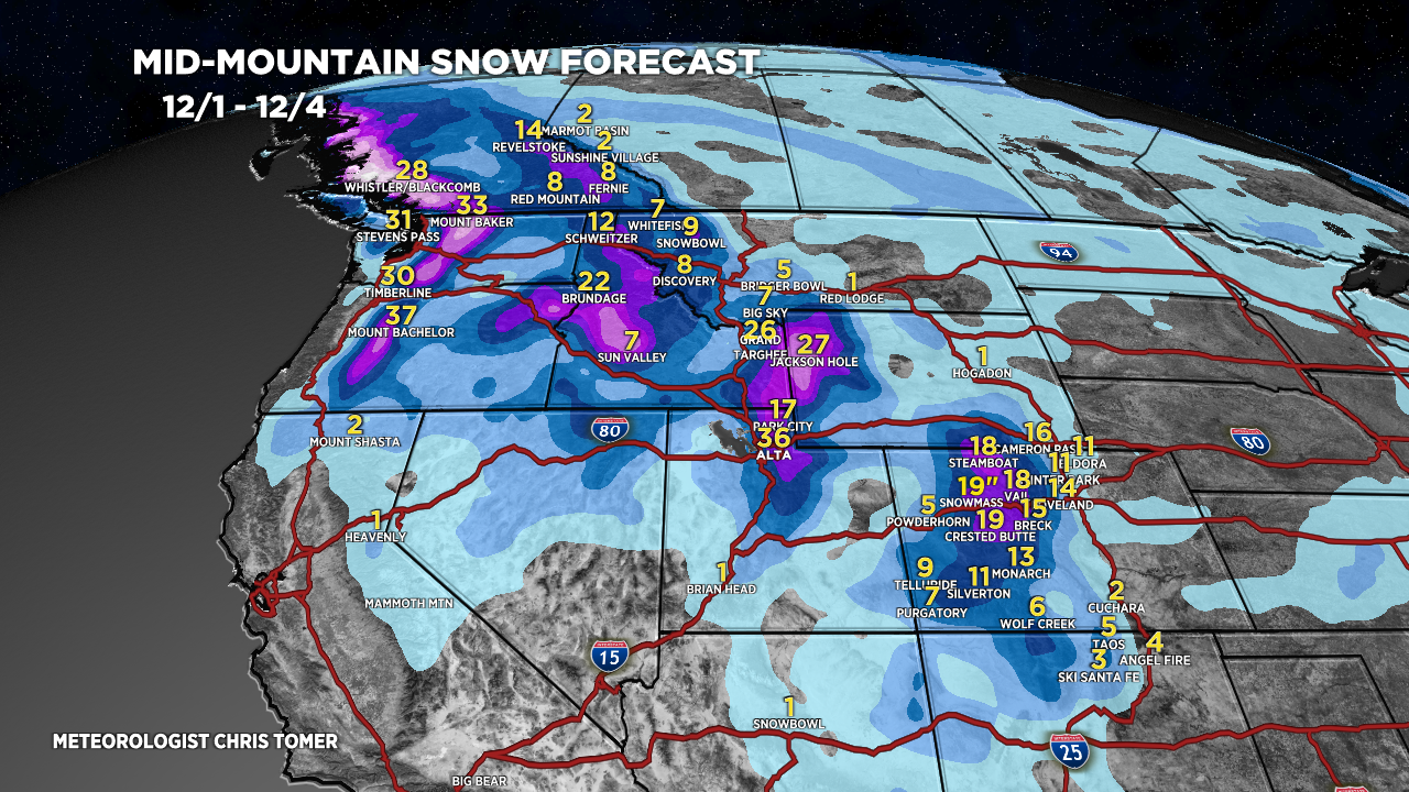
*2:30pm 12/1 Update: Bulk of accumulation in Colorado and Utah arrives Saturday evening (12/2) through Sunday (12/3).
Tomer’s Take: The ‘golden combo’ of a moderate to strong intensity atmospheric river, stacked WNW Flow, and high ratios is underway in PNW, BC, ID, WY, UT, and C+N Colorado mountain zones. It’s a three day event, 12/1-12/3, with snow lasting into 12/4 in the Tetons. 1-3 feet at many ski resorts.
My forecast update:
About 6 inches at Aspen Mountain with another foot or more to go.

Current Setup
Water vapor satellite shows the moderate to strong intensity atmospheric river slamming into the PNW with downstream benefits.

Atmospheric River
Forecast Integrated Vapor Transport (IVT) for the WA/OR coast 46.5N/124W. ‘Moderate to strong intensity’.

Forecast Jet Stream
Valid 12/2. Powerful WNW Flow stacked to 10k.

Valid 12/9. Deep trough sinks far to the south and might cut-off.

Forecast Radar & Satellite
Forecast Totals
*Updated 2:30pm 12/1: Additional Snow Accumulation
Bulk of snow accumulation in Colorado and Utah occurs Saturday evening (12/2) through Sunday (12/3).

Jackson Hole, WY snow plume, accumulation over time.

*Updated 2:30pm 12/1.

*Updated 2:30pm 12/1.
VT/NH/ME Snow: Late 12/1-12/2 (Light), 12/3-12/4 (Moderate to Heavy).

Thanks again for your dedication to providing these ski weather reports.
love it.
Thanks, Kevin! Chris
Thanks for the GREAT Anniversary gift Chris!🙌❄️❄️❄️❄️
Thanks, Holly! Chris
You are the best meteorologist! So accurate and when a little off, you own it! I like that.
Thanks, Shelley! Chris
Shelly the MVM is never off . Dude is on point each and every time. Only JC himself could predict Mountain Weather more accurately.
Thanks as always, Randall! Hope you’re well. Chris