*Updated 2pm 11/30. Forecast is on track, no big changes.
Tomer’s Take: A golden combination of jet power, stacked WNW Flow, and moderate to strong intensity atmospheric river (AR) contribution delivers 1-3 feet of accumulation in parts of the PNW, BC, ID, WY, UT, and CO. My forecast numbers for CO are back up – I think the AR contribution and air temps are enough to close the gap.
My forecast video:
Current Setup
Water vapor satellite shows the moisture aloft loading-up with an atmospheric river (AR) reach.
Orange/red = drier air aloft. Moisture = white/blue.

Forecast Jet Stream
Valid 12/2. Powerful WNW Flow stacked down to 10k.

Valid 12/9. Storm system with amplified jet sliding through the interior Rockies.

Atmospheric River
Forecast Integrated Vapor Transport (IVT) valid through 72 hours ending 12/5. The fetch of moisture transport can be traced through the very western Pacific basin.

Forecast IVT valid next 10 days for OR/WA coast at 46.5N/124W. Moderate to strong intensity atmospheric river contribution is likely.

Forecast Radar & Satellite
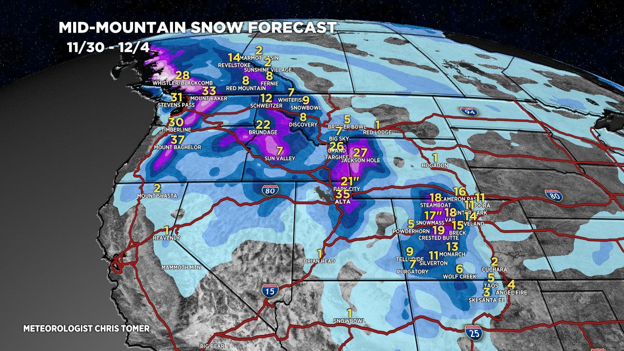
Forecast Totals
*Updated 2pm 11/30. Forecast is on track, no big changes.
CO Snow: Late 11/30-12/3.
UT Snow: 12/1-12/3.
WY Snow: 12/1-12/3.
PNW Snow: 12/1-12/6.

*Updated 2pm 11/30.

Forecast Snow Accumulation Over Time for mid-mountain Jackson Hole, WY.

*Updated 2pm 11/30.
VT/NH/ME Snow: 12/1-12/2 (Light to moderate accums), 12/3-12/4 (Heavy).

Thank you for all your work on these forecasts. I love getting the email delivery and you help me plan my travels. Off to Targhee this weekend!
Thanks, Kevin! Have a great trip to Targhee and enjoy this very promising storm cycle.
Chris
Thanks Chris, nice to finally see some snow on the way to the wasatch. It’s very dry over there.
Thanks, Jim! I agree, this is exactly what we need. Chris
Really appreciate all your hard work. Fyi nm got a little more than forecasted .. always a bonus!
Thanks, Derek! Chris
This storm on top of ice pack will certainly kick up the Avi
danger out there.
Thanks, CW! No doubt! Chris