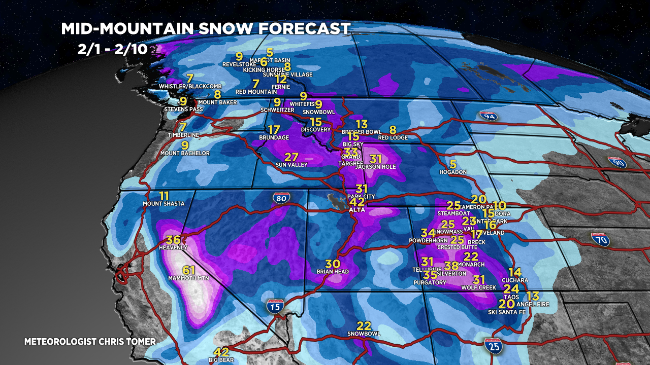
Tomer’s Take: Heavy snow continues in the Sierra with storm #1. This storm then moves into UT/WY/ID/MT/CO/NM through 2/4. A Panhandle Hooker storm system develops near the TX/OK panhandles on 2/3. This storm system enhances snowfall totals across parts of CO and NM. Storm #2 delivers a moderate intensity atmospheric river (AR) surge to CA 2/4-2/5. This storm then moves into UT/ID/WY/MT/CO through 2/8. Big grand totals likely measured in feet in CA/UT/WY/CO.
My afternoon forecast video update:
Current Setup
Water vapor satellite shows three different storm systems lined-up in the Pacific riding a powerful Subtropical jet stream.
Red/orange = drier air aloft.

Old Man Winter Rally 2/4
Event takes place in Lyons, CO on 2/4.
2/2: Increasing clouds, rain to snow after 10pm, gusts under 15mph, 37/46F.
2/3: 2-4 inches (mixing with rain), gusts under 15mph, 34/38F.
2/4: Turning drier, wind gusts under 15mph, 32/40F.
Forecast Atmospheric River (AR)
Forecast Integrated Vapor Transport (IVT) valid for the South/Central CA coast. Notice the moderate AR surge with storm #2 on 2/4-2/5.

Forecast precipitable water content valid 2/3-2/4. The atmospheric river surge/plume is obvious.
This could result in eight inches of rain in Los Angeles 2/4-2/5.

Forecast Jet Stream
Storm #1 moves into UT/WY/CO/ID/MT/NM.

Storm #2 and trough sliding out of CA into UT/ID/WY/CO/NM.

Forecast Radar & Satellite
Forecast Totals
Grand Total snow by 2/10.

Bulk of snow timeline:
UT: 2/2
CO: 2/2-2/3
WY: Late 2/2 – AM 2/4

Bulk of snow timeline:
UT: 2/5-2/7.
CO: 2/6-2/9.
WY: 2/5-2/7.


Hey Chris! Really appreciate you and your forecasts!
I’m seeing the total for Wolf went down from 52” total to only 31” total from yesterday to todays update. Big difference? Seemingly everywhere else went up a lot. Why the big drop for Wolf? Thanks!
Hi Brian – It mainly has to do with the 2nd storm system 2/6-2/8. As track of storm system changes so does the key snowmaking wind direction. We’ll see what the track looks like tomorrow. Chris