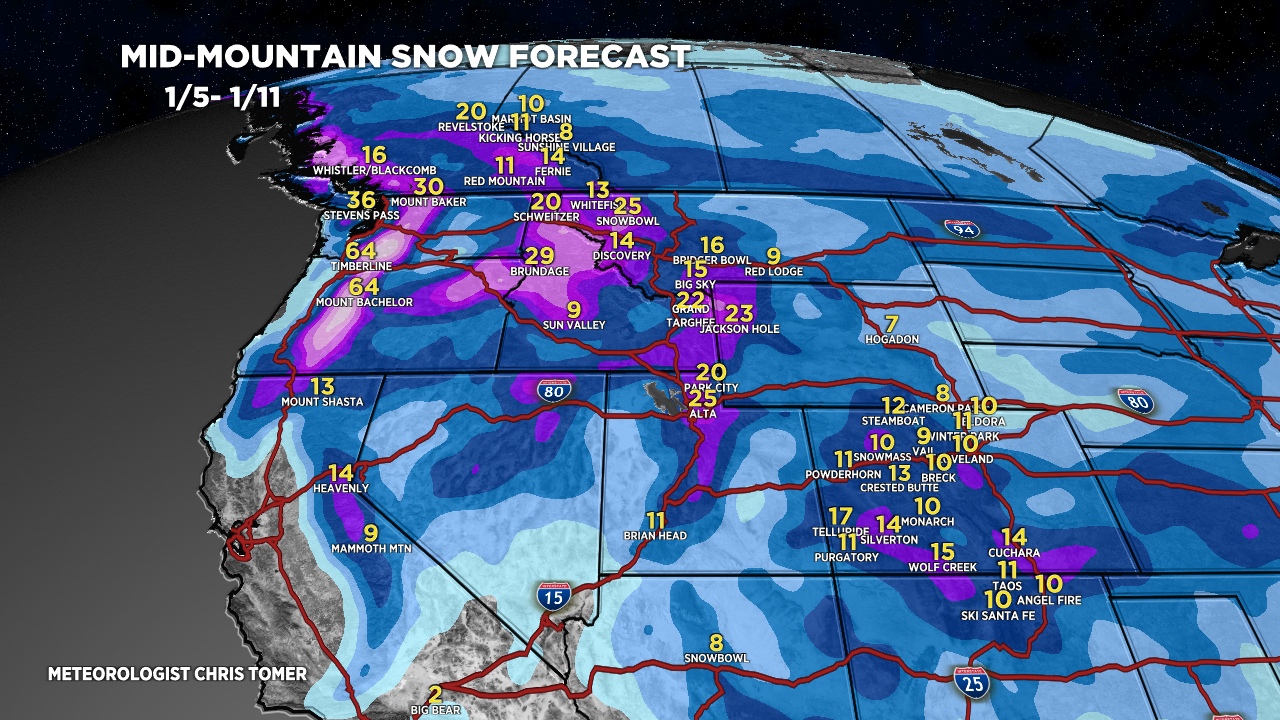
Tomer’s Take: A major Western pattern shift delivers colder air and big snow totals 1/5-1/11. It’s comprised of vanguard snow 1/5 then two storm systems. #1 occurs 1/6-1/8 followed by #2 on 1/9-1/11. Before all that happens, a storm system hits the Sierra late 1/2-1/3 then takes a southern track through AZ/UT/CO/NM 1/3-1/4.
In the Northeast, the 1/7 stormtrack continues to wobble. If it wobbles back to the north then snow totals increase VT/NH/ME. Another large storm system is possible 1/9-1/10.
My afternoon forecast video update:
Current Setup
Water vapor satellite shows two large storm systems in the north Pacific. The first storm system hits the Sierra late 1/2-1/3 then takes a southern track 1/3-1/4 through AZ/UT/CO/NM. The 2nd powerful storm system is the pattern changer.
Orange/red = drier air aloft.

Forecast Jet Stream
Valid 1/5. First key snow window is 1/5-1/8. The northern branch buckles south with a pattern changing area of low pressure. Vanguard snow races through the Intermountain West.

Valid 1/8. First trough moves east of the Rockies. This marks the end of key window #1. Key window #2 arrives 1/9-1/11.

Valid 1/10. Northern branch buckles south with 2nd large trough. Snow and cold.

Forecast Radar & Satellite
Forecast Totals
CA Snow: Late 1/2-1/3. Rain/snow line starts at 7000′ then drops to 5000′.
UT/AZ Snow 1/3-1/4.
CO/NM Snow: 1/4-1/5.

Forecast includes two storm systems. Key snow windows: 1/5-1/8, 1/9-1/11.

1/7 stormtrack continues wobble. If it wobbles north then snow totals increase VT/NH/ME.
Another large storm system possible 1/9-1/10.

Thanks for your weather forecasts. I really enjoy them.
Happy to see we will see some snow in Gunnison. Sorely lacking at the moment!
Thanks, Jennifer! Chris