Tomer’s Take: Snow continues on 12/14 across Southern Colorado and Northern New Mexico. Then this storm system departs and develops into a strong East Coast storm system 12/17-12/20 with wind, rain, and snow.
Looking down the road, light to moderate snow hits the Sierra late 12/17-12/18 with high rain/snow levels. Light snow hits the Wasatch 12/19-12/21. A more active pattern might develop after 12/23.
Current Setup
Water vapor satellite shows the storm system in Southern CO/Northern NM. It also shows a large Pacific trough that will slowly work its way towards CA.

Forecast Jet Stream
Valid 12/17. Trough and moisture approaches CA coast, slowly. Warm air floods the West generating high rain/snow line.

Valid 12/23. A transition point as Pacific delivers energy. Pattern turns more active.

East Coast Storm System
Valid 12/17. Jet supports a strong area of low pressure, but it lacks cold air. Rain and wind dominate through 12/18. Then colder air turns rain to snow in NY/VT/NH/ME.

Valid 11:15pm 12/17.

Forecast Radar & Satellite
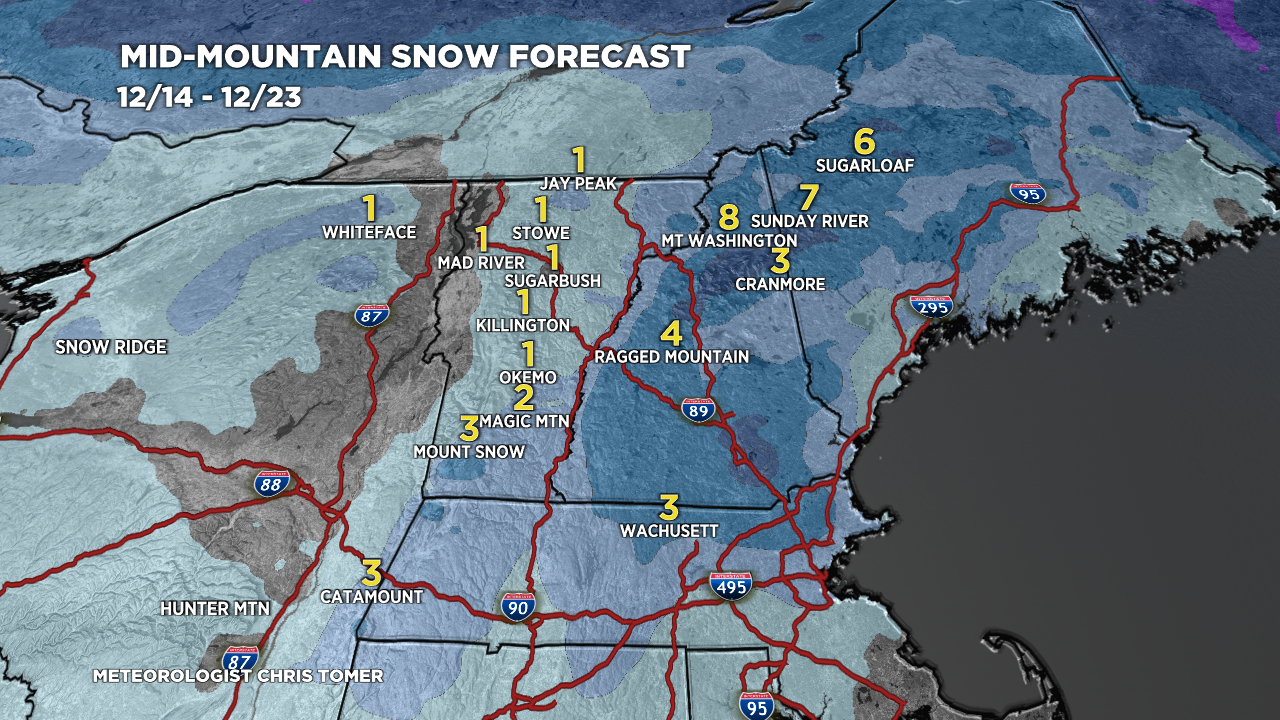
Forecast Totals
*Updated 2pm 12/14.

*Updated 2pm 12/14.
CA Snow: Late 12/17-12/18 (Light to moderate).
UT Snow: Late 12/19-12/21 (Light).
CO Snow: Late 12/20-12/21 (Light).

*Updated 2pm 12/14.
NY/VT/NH/ME —>
Late 12/17-12/18: Rain
12/19-12/20: Snow possible.

Greetings from the mid-west,
Excited to see the pattern shift . Hoping for Tahoe and PC snow Dec 28-Jan 14. I have my 4 leaf clover , rabbits foot, and horseshoe packed in the ski bag. Thanks for the detailed forecasts, and being the MVM=Most Valuable Meteorologist . Undefeated and undisputed!
Thanks, Randall! Glad your dates are later and after Christmas. Hope we have a new pattern by then with colder air. Chris