Tomer’s Take:
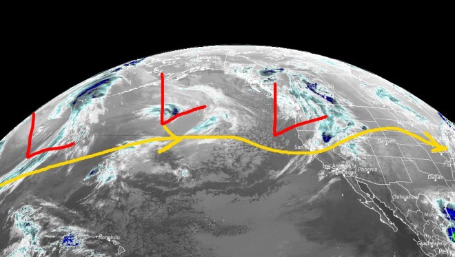
- The storm track continues to favor the West with a few storm systems lined-up through 5/5.
- The proximity of the jet stream through 5/5 keeps strong wind in the forecast.
Infrared satellite shows the active storm track and storm systems over the Pacific.
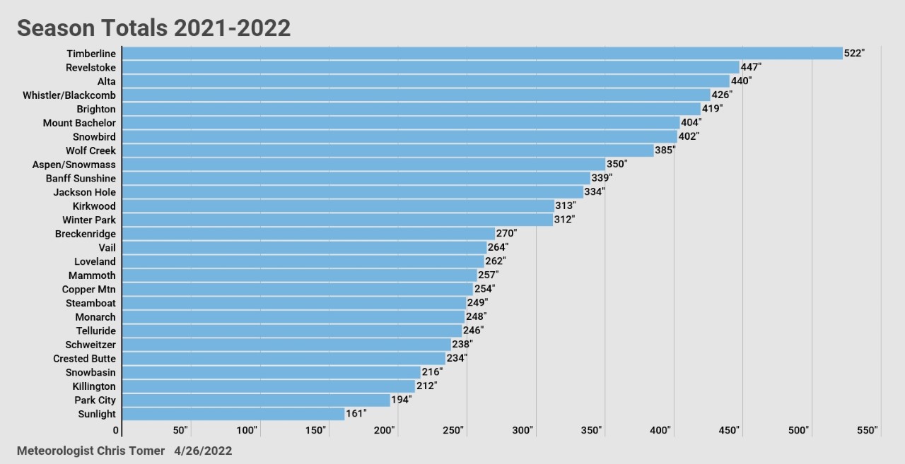
Season Totals 2021-2022

A few highlights:
- Alta 440″
- Wolf Creek 385″
- Sunshine Village 339″
- Jackson Hole 334″
- Winter Park 312″
- Vail 264″
- Loveland 262″
- Steamboat 249″
- Telluride 246″
- Crested Butte 234″
- Park City 194″
Early May
An active jet stream and lower pressures appear to dominate the West through 5/5. If this plays out then the odds of rain/snow in mountainous areas stays high.

Wind Gust Forecast
In Colorado, the last three weeks have been one for the books. The proximity of the jet stream has followed La Nina architecture. The latest forecasts keep La Nina going strong through Spring into Summer.
| Gust (MPH) | 4/26 | 4/27 | 4/28 | 4/29 | 4/30 |
| Crestone Peak | 60 | 60 | 40 | 70 | 55 |
| Quandary Peak | 35 | 35 | 25 | 50 | 40 |
| Kings Peak | 45 | 45 | 50 | 45 | 25 |
| Wheeler Peak | 40 | 45 | 30 | 60 | 40 |
| Mount Whitney | 35 | 25 | 45 | 30 | 30 |
| Grand Teton | 45 | 35 | 35 | 40 | 20 |
Snow Forecast
4/26-4/30:

5/1-5/5:

Thanks Chris! Looks like we could have a few more snowy days up here!
You bet, Vickie! Chris
346″ for Irwin lodge
Pretty big change from CB just 8 miles away.
Thanks, Robert! Chris
This was my first snow season following your blog. Very informative and I will continue to follow your weather blog.
Thanks, Trini! Chris
Hey Chris, thanks for the outlook and the ski area snowfall totals. I’m curious how they landed as compared to average. Is it possible to add that to the graph? Thanks for all you do!
-Dan
Thanks, Dan! I found my Winter forecasts from August/September 2021. There were hits and misses as usual. You’re right, it will make for a good post. Chris