Tomer’s Take: The next wave of snow hits UT/WY/CO afternoon 1/10 through 1/11. Then another storm system and Arctic front hits the West 1/12-1/15 with strong orographics, high snow ratios, and a jet blast. Snow squalls are possible in UT & CO 1/12-1/14. Another storm system 1/16-1/19 hits BC/MT/ID/WY/CO with a NW type flow.
In the Northeast, a powerful storm system arrives 1/12-1/13 (not unlike the 1/9-1/10 bomb cyclone) with 70mph gusts and heavy snow changing to rain/snow at the major ski areas. Another storm system on 1/16-1/17 is not looking as impressive as it did in this mornings update.
My afternoon forecast video update:
Current Setup
Water vapor satellite shows a strong area of low pressure traversing the West. An Arctic front is lurking to the north.
Orange/red = drier air aloft.

Forecast Jet Stream
Valid 1/11. Trough and storm system departs CO/NM.

Valid 1/13. Powerful merger of northern and southern jet with Arctic front. Max orographics and snow ratios likely and WNW flow orientation.

Valid 1/17. Final storm system 1/16-1/19. Heavy snow favors ID/WY/MT/CO with WNW flow orientation.

Forecast Wind Gusts
Valid 1/12 at 4pm. 50-70mph gusts on Colorado’s high peaks. Gusts would be similar on Saturday 1/13 in the morning.

Mount Superior, UT:
1/12: 60mph
1/13: AM 40-50mph, PM 25mph
Grand Teton, WY.
1/12: 60mph
Forecast Radar & Satellite
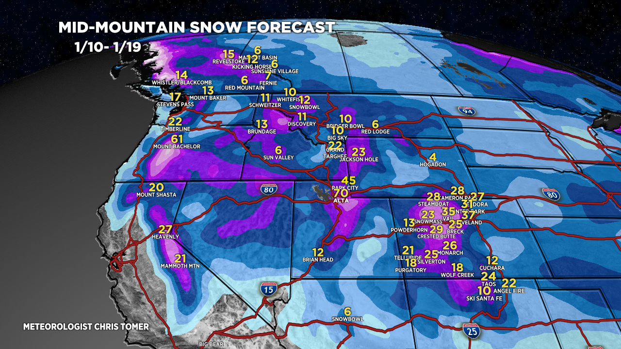
Forecast Totals
Grand Totals from three different storm systems.


Northeast:
Next storm system 1/12-1/13.
Storm system 1/16-1/17 is looking weaker – that’s why these numbers have decreased.

Great stuff Chris! We are scheduled to fly into Vail/Eagle on Saturday 1/13, landing around 11am local time. Think there will be any issues? Thanks again 🙂
Hi Tom, strong wind and snow likely for the Vail area on 1/13. Snow squalls possible. Further west in Eagle, it won’t be quite as severe but you’ll still have snow and wind. Chris