Tomer’s Take
- Active storm track with 2-3 different storm systems through 12/26 for the West.
- California gets a weak to moderate intensity atmospheric river. Several feet of accumulation by 12/26 at mid-mountain elevations and higher.
- Widespread 1-2 foot totals at UT, WY, ID, and CO ski areas by 12/26.
Current setup: Notice the large low pressure (red low) just off the West Coast. This trough of low pressure will intensify (deepen). All the other low pressures will then rotate around the high into this trough and hit the West Coast and later the Interior Rockies through 12/26.

On Christmas, a large trough of low atmospheric pressure dominates the West.

Snow Forecast
Let’s look at my snowfall forecast in two-timeframes.
12/20-12/22:

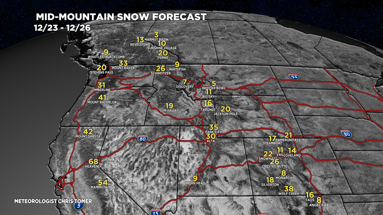
12/23-12/26:

- In Colorado, I like the Western Slope ski areas for the biggest totals.
- In California, snow levels will rise to 5,000ft. So the higher the better for powder.
- In Utah’s Wasatch, you might have new snow each day from the 12/23-12/26 for big grand totals.
Let’s drill down, here’s my snow plume forecast for Crested Butte, CO.

For more analysis please watch my forecast video:
Wow! Finally! So exciting to see your totals for the mountains.
I totally agree, Heidi! Chris
Make it snow in Denver! Want to see snow!!!! Ok, got that out! Thanks for the in depth Chris, unfortunately I DO NOT ski.
Snow has been hard to come by in Denver so far. Have a great Christmas, Patricia. Chris
Hey Chris, thanks for all the great videos. We notice you do the totals now in several day blocks, when before there was hourly build up. Is there a way to revive the hourly? It truly is useful in planning the drive when chasing powder.
Keep fighting the good fight.
Thanks, Bill. That’s something i’d like to do down the road if I do this full-time. Best, Chris