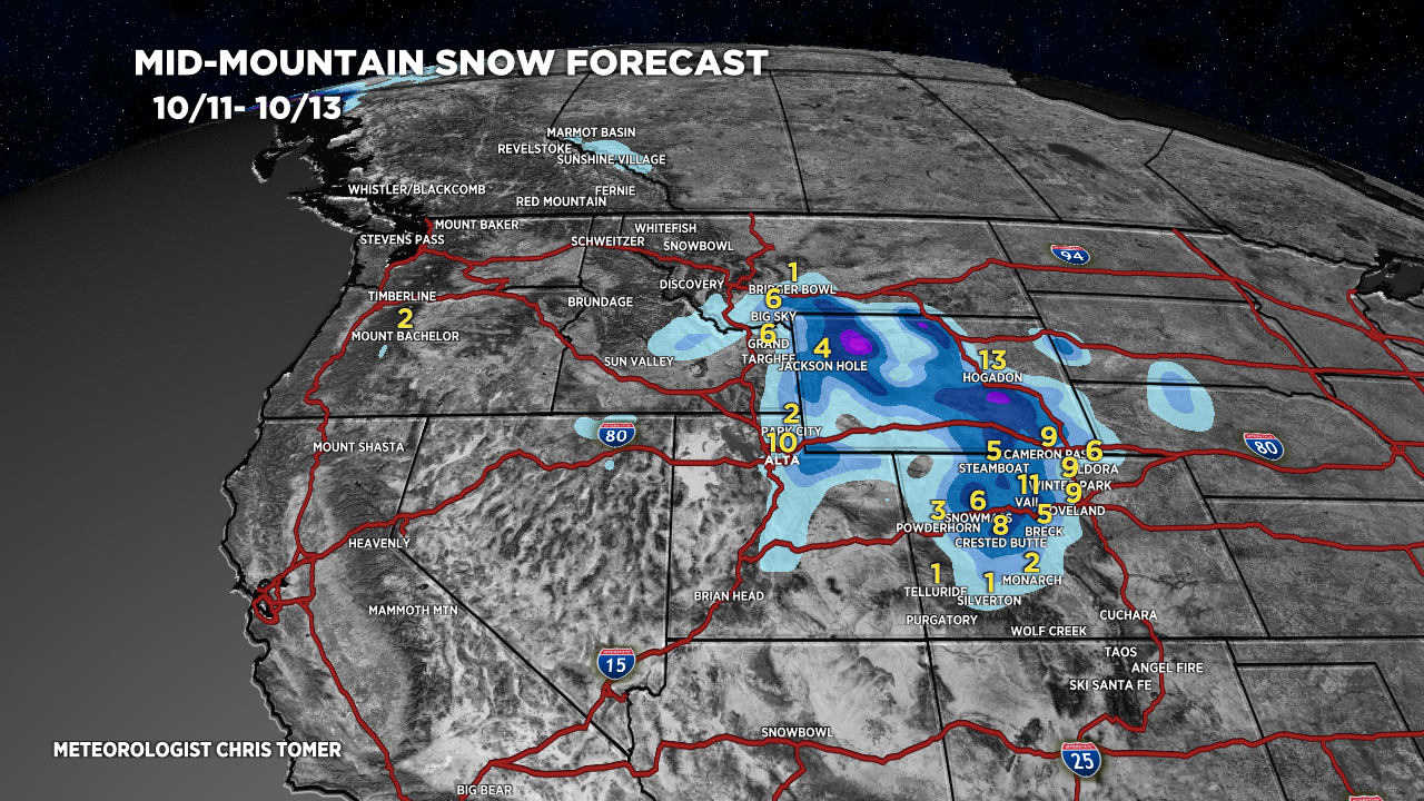
Tomer’s Take: A storm system with snow for UT, WY, CO hits 10/11-10/12 along with a 15-30 degree temperature drop. The track of the storm continues trending slightly further north into WY. This has increased forecast totals for WY and parts of UT.
The mountain towns of Aspen and Vail start as rain then change to snow late 10/11 into 10/12.
The mountain town of Steamboat Springs stays mainly rain.
Full Forecast Video
Current Setup
Water vapor satellite shows the dipping jet and areas of low pressure lined-up. Red/orange = drier air aloft.

Forecast Jet Stream
Forecast jet stream velocities valid 10/12. Notice the dip in the jet supporting an area of low pressure. This is the first significant snow for the mountains of UT, WY, and CO.

Forecast Snow
*PM 10/11 updated forecast totals.
Forecast mid-mountain snow forecast valid 10/11-10/13.

Forecast Rain/Snow Line
Wasatch Mountains, UT
10/11: 9200’/7200′ (max/min)
10/12: 8200’/7200′
Central Mountains, CO
10/11: 13000’/9200′
10/12: 8400’/7100′
Teton Range, WY
10/11: 9000’/7900′
10/12: 8900’/8200′
Forecast High Peaks
Kings Peak, UT
10/11: 2-3″
10/12: 4-8″
Grand Teton, WY
10/11: 1-2″
10/12: 4-6″
Maroon Bells, CO
10/11: 3-6″
10/12: 4-6″
Mount of the Holy Cross, CO
10/11: PM 3-6″
10/12: 4-6″
Longs Peak, CO
10/11: PM 2-3″
10/12: 1-3″
Quandary Peak, CO
10/11: PM 1″
10/12: 2-4″

Chris I have been following you for about a year everyday during the ski season. I am an instructor in the snow sports school at Red Lodge Mountain in Montana. I was wondering if you might add Red Lodge to your forecast map? I know I would appreciate it and many of our skiers and snowboarders from the upper Midwest would like to see it as well. Thanks for considering it. g
Thanks for reaching out, George! I’ll put Red Lodge on my to-do list.
Chris
Hey Chris. Hope all is well with new old gig. Looks like this storm over-delivered for the divide….Abasin/Luv. Looking forward to opening day soon!
Thanks, Claye! Yes sir. This upcoming week looks active with three separate cold fronts. Chris