Tomer’s Take: Two different storm systems are lined-up 2/1-2/8 both riding a powerful Subtropical jet. Storm #1 (2/1-2/4) delivers a moderate intensity atmospheric river surge, widespread snow across the interior Rockies, and possible panhandle hooker storm system for Colorado (on 2/3). Storm #2 (2/5-2/8) could be strong for CA, then moves into the interior Rockies with another round of snow accumulation.
In the interim, abnormally warm temps continue with high freezing levels: 6-9K PNW/BC, 8-11K UT/CO.
My afternoon forecast update video:
Old Man Winter Rally 2/4
Event takes place in Lyons, CO on 2/4.
2/2: PM Rain to snow (1 inch late), gusts under 15mph, 38/41F.
2/3: 3-6 inches, gusts under 15mph, 32/35F.
2/4: AM flurries then drier, 29/36F.
Current Setup
Water vapor satellite shows the rich feed of moisture directed into the PNW/BC and large trough waiting in the North Pacific. This trough breaks loose and rides a powerful Subtropical jet into the West 2/1-2/8.
Orange/red = drier air aloft.

Forecast Atmospheric River
Forecast Integrated Vapor Transport (IVT) valid next 10 days for C/N CA Coast, 38N/123W. Notice the moderate intensity AR surge PM 1/31-2/1 with storm #1 and 2nd possible weak surge 2/5-2/6 with storm #2.

Forecast Jet Stream
Storm #1 arrives in CA with a powerful Subtropical jet then moves into the interior Rockies.

Deep trough off CA coast with Storm #2. Rapid intensification.

Forecast Radar & Satellite
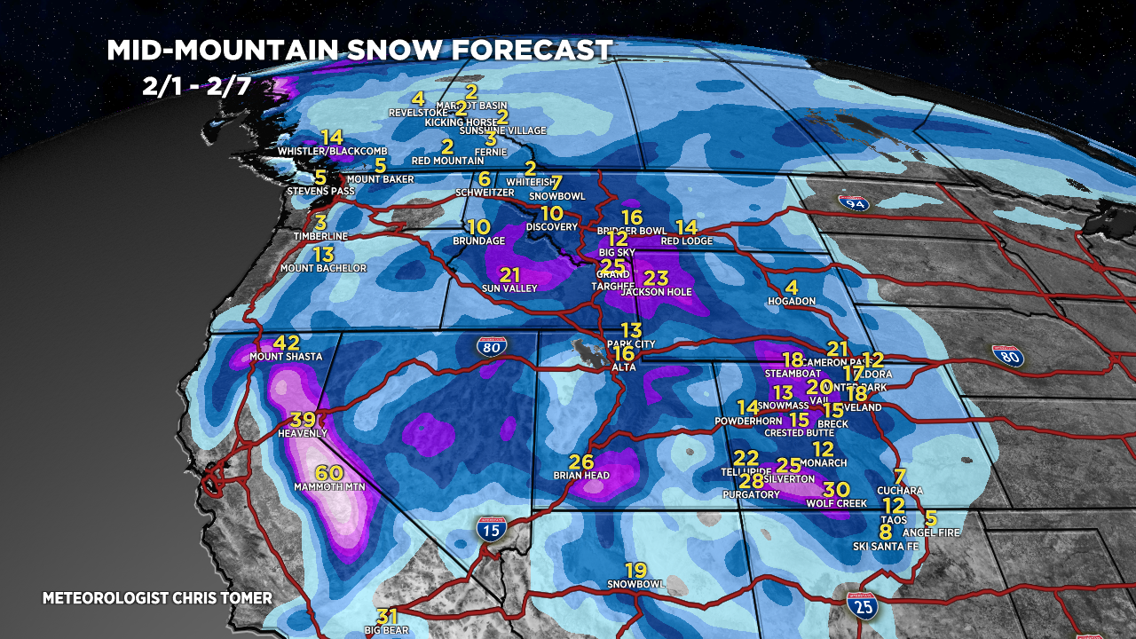
Forecast Totals

Grand Totals 2/1-2/7: Storm #1 + Storm 2.

Storm #1. Watching for a Panhandle Hooker storm system in Colorado on 2/3.

Storm #2.

Northeast:
Light snow 2/1-2/2.

Panhandle hooker you say – I think I know her.
;-D
First time really chasing something deep this year. Just booked wolf creek for first time 9-12th. We’ve skied deep powder before but nothing like what we might up there. What’s your advise on the fat skis as we have never used them before?
Hi Brandon –
It’ll be a solid run for Wolf Creek with two storm systems. You’ll get there at the very tail-end. Thinking 2-3 feet between 2/1-2/8.
Chris
As mountain is flat….aka Pancake Creek…..point it last 3rd or you will get stuck.