Tomer’s Take: A three storm cycle hits the West 1/6-1/14. Big grand totals. The #3 storm system drags down the coldest air of the season from the Arctic. Air temps by 1/13-1/15 run 30 to 50 degrees below the 30year average with many places below zero.
All three storm systems ride a powerful jet stream into the Northeast. Precipitation chances include 1/6-1/7, 1/9-1/10, and 1/12-1/13.
My forecast video update:
Steamboat and Winter Park, CO are reporting 5 inches in the last 24 hours from a southern track storm system.

Current Setup
Water vapor satellite shows vanguard light snow with a front racing through the Intermountain West. It also shows the pattern changing low in the north Pacific/Gulf of AK.
Orange/red= drier air aloft.

Forecast Jet Stream
Storm #1. Deep trough and colder air.

Storm #2.

Storm #3. Deep trough and Arctic Blast rotates south.

Arctic Blast
The #3 storm system drags down an Arctic Blast across the West 1/13-1/15. This is a major trough in the atmosphere. Air temps run 30 to 50 degrees below the 30year average with many places below zero.
Below is forecast air temperature anomalies valid 1/14.

Forecast Radar & Satellite
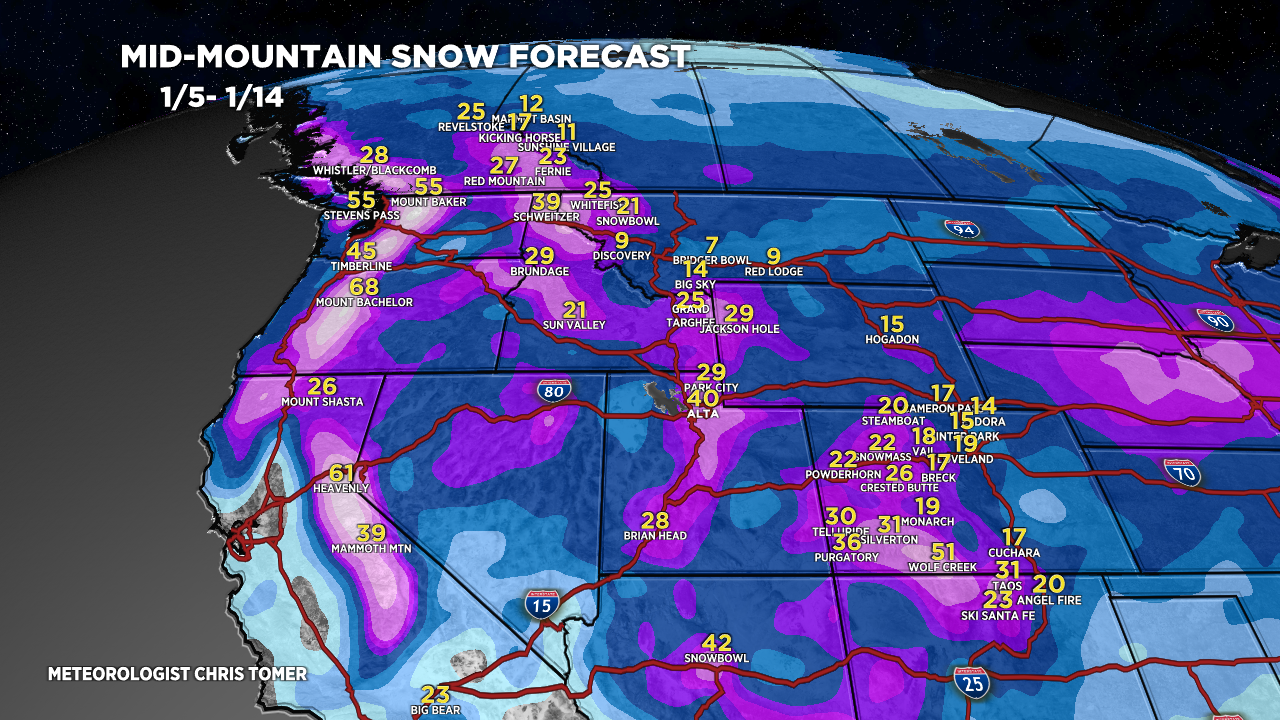
Forecast Totals
Grand Totals by late 1/14 from Storm #1+Storm#2+Storm#3.

1/5-1/8.

1/9-1/11.

1/12-1/14.

Grand Totals by late 1/14 in Southern Colorado. Snow all the way down to the valley floor in Durango and Bayfield.

VT/NH/ME Snow: 1/6-1/7, 1/9-1/10, 1/12-1/13.

On the money for 1.5 in at PC yesterday. Looking forward to all that Tahoe snow next week! Thanks for the New weather for the new year!
Thanks, Randall!