Tomer’s Take: A dip in the jet stream delivers a strong cold front and area of low pressure to Colorado, Utah, and Wyoming between 10/11-10/12. Light accumulation in Utah and Wyoming. Heavier accumulation in Colorado (4-8″). Air temps drop 15-30 degrees.
The bulk of the snow accumulation in CO stays above 10,000ft in the Central and Northern Mountains, but snow accumulation is also possible between 8000-10,000ft at many mountain towns including Aspen and Vail where it will start as rain then change to snow. Steamboat Springs stays mostly rain.
Jet Stream
A buckling jet stream delivers colder air, falling snow levels, a strong cold front, and developing area of low pressure.
Below is forecast jet stream velocity valid early 10/12.

Moisture
Absolute moisture and relative humidities increase 10/11-10/12.
Below is forecast relative humidity at about 10,000ft. Saturation is likely from Denver vertically through the 14ers. Notice the highest moisture (darker colors) favor the Central and Northern Mountain zones.

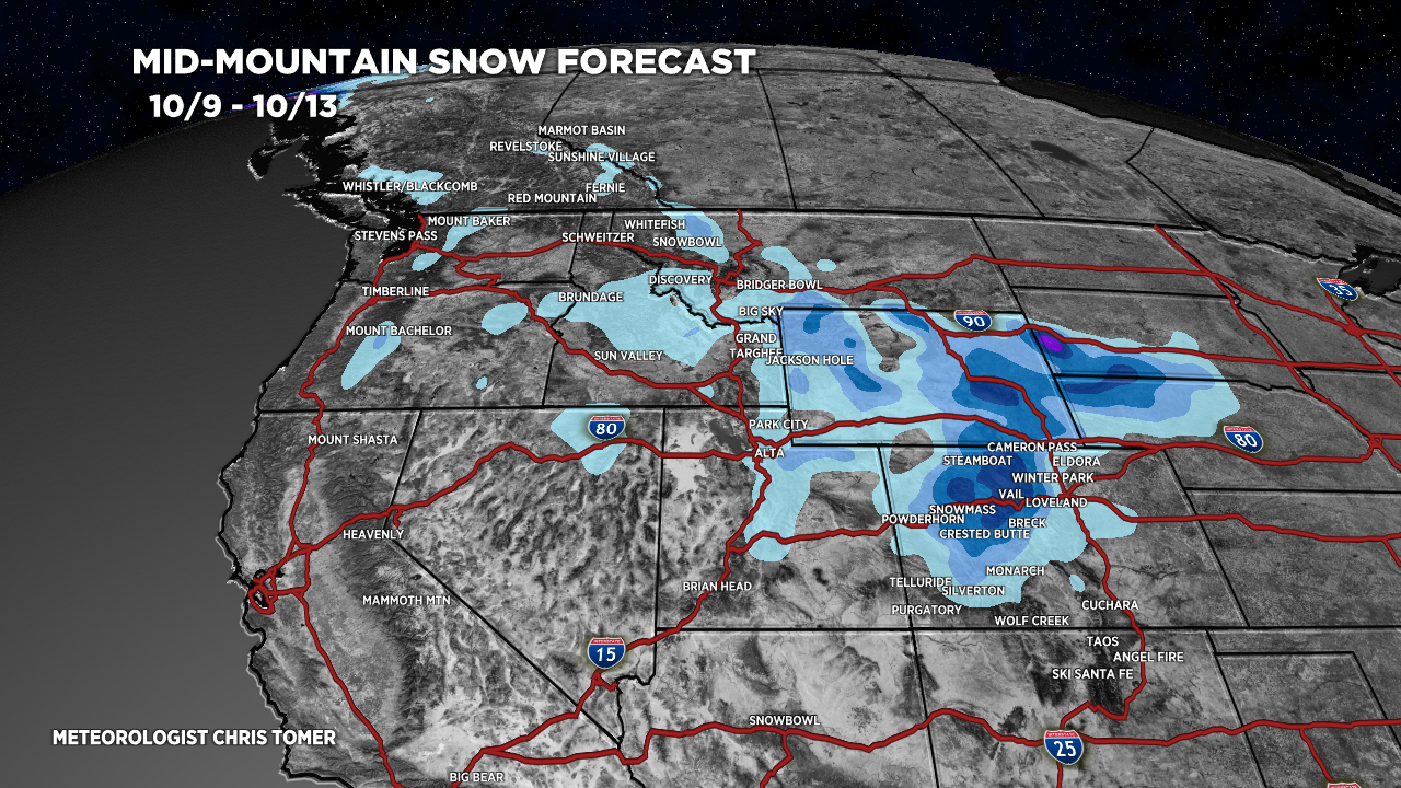
Snow Forecast
Forecast snow accumulation. Notice the heaviest accumulation occurs in Colorado. The darkest blue band = 4-8 inches. Lightest blue band = 1-3″. Magenta = 6-12″+.

Forecast radar snapshot valid 10/12 at 6am. Full forecast radar loop is at bottom of post.

High Peaks Forecast
Grand Teton, WY
10/10: 1″ late
10/11: 1-3 inches
10/12: 1″
Kings Peak, UT
10/11: 1″ late
10/12: 1″ Early
Maroon Bells, CO
10/11: PM 1″
10/12: 6″+
Mount of the Holy Cross
10/11: PM 1-3″
10/12: 6″+
Longs Peak
10/11: 1″ late
10/12: 4-6 inches
Quandary Peak
10/11: 1″ or less
10/12: 2-6 inches
Well the start of another season , and so far it’s looks painful in the Canadian Rockies and southern BC.. AS ONLY 80% of normal is expected as you and anyone talking snow appear to agree, however if that happens it would be a step up from last years 60 or less in some places..🫣 any hopeful comments greatly accepted
Hi Jim! Another season is here – thanks for checking back in. This ‘super strong El Nino’ doesn’t favor the Canadian Rockies, unfortunately. November and December should generate at least normal snowfall then snow trends lower in Jan-Feb-Mar. Chris