Tomer’s Take: Major storm system remains on track for Colorado afternoon 3/13 through morning 3/15. I’m forecasting 1-3 feet of total snow accumulation on the Continental Divide-East above 6,000ft, Foothills, Western Suburbs, Palmer Divide, and Southern Colorado. Northern New Mexico could see 10-20 inches.
Denver starts as rain 3/13 then changes to snow overnight into 3/14 and trickles into early 3/15. This will be heavy/wet back-breaking snow. Significantly less accumulation across Fort Collins, Loveland, and Greeley.
Timing
*Updated 4pm 3/13/2024.
Classic Colorado March snowstorm on track.
1-3FT (or more) Tonight – 3/15 Divide-East above 6,000ft, Foothills, Palmer Divide.
Tetons: Next Storm System 3/21-3/23.
Wasatch: Next Storm System 3/21-3/23.
Northeast: Rain Tonight, 3/15, R 3/17, Snow 3/18.
My afternoon forecast video update:
Current Setup
Water vapor satellite shows the main storm system pivoting out of UT/WY and into CO.
The 2nd low over the Pacific plays a role in a pattern shift after 3/20.
Orange/red = drier air aloft.

Forecast Radar & Satellite
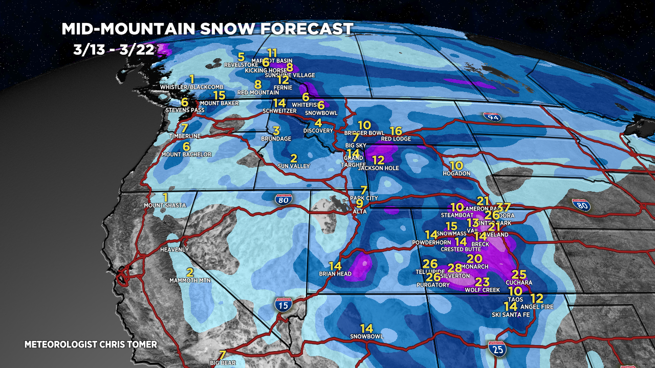
Forecast Totals
Grand totals by late 3/22.


Northeast:
VT/NH/ME: Rain 3/15, 3/17. Snow possible 3/18-3/19.

Hey Chris,
Thanks for all your daily videos and blog posts they are very helpful when planning a trip. I am going to Colorado to ski from March 21st to the end of the month. Have ikon pass so going to ski Copper, A-basin, Winter Park, and maybe steamboat. Do you believe it will rain at all during the period I am there? I know it’s going to be slightly warmer from after this storm until I get there when that cold front hopefully drops as you’ve mentioned the last couple days.
Thanks for the help!
Ryan
Hi Ryan! 3/16-3/20 is quieter, but the current storm system gets cut-off from the main flow and will send random waves of snow into SW CO during that time period. Next pattern change with snow for the resorts you mentioned arrives 3/21-3/23.
What a great mountain weather update today! Hopefully getting out to CO for next weeks storms.
You should see the look on the wife’s face everyday I play your videos. Priceless. “Hey guys…”.
Thanks, Randall!