Tomer’s Take
- Merger of two different storm systems next 72 hours over 4-Corners marks the final piece of this historic storm cycle.
- Cold blast follows this merger.
- Brief break in the action across Intermountain West with small high pressure Sunday-Monday. Then next Pacific storm system hits the Intermountain West after 1/4.
- Grand total storm cycle snow in Crested Butte, Silverton, Wolf Creek, and West Elks around Aspen/Snowmass should range from 100-130″ (12/23-1/1).
- Wolf Creek Pass and Schofield Pass already showing 10″ of SWE.
Infrared satellite shows the storm track and both storm systems involved in merger.

Forecast mid-mountain air temperatures (F) Saturday and Sunday morning:
| Mid-Mountain | 1/1 | 1/2 |
| Alta | 0 | -7 |
| Loveland | 0 | -19 |
| Snowmass | 8 | -15 |
| Jackson Hole | -7 | -2 |
| Crested Butte | 7 | -20 |
Snow Forecast
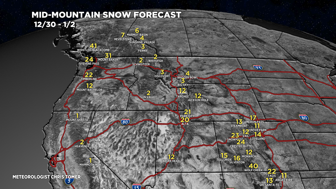
Let’s look at my snow forecast in two time-periods. I added Winter Park and Ski Santa Fe to the map.
12/30-1/2:

1/3-1/8:

Drilling down, here’s my snow plume for Winter Park.

For more analysis please watch my forecast video:

Could you add brundage to your map? Central Idaho bw sun valley and Schweitzer. Interesting snow track usually – it gets snow from most major storms but not the storm totals of other spots in the mtn west. I find that fascinating.
Thanks, April! I’ll add Brundage to my list. Chris
I am reading this correctly that for the Steamboat Zone you’ve lowered the merger payout by 10 inches or so? Winds not going to be favorable?
Thanks, Andrew…yes final payout appears lower to me as the storm track keeps shifting a little further south. Chris
Great report – keep ’em coming!
Thanks, Nancy! Chris
Hey Chris!
Love all your content, we follow your daily reports closely up here and with Snowmass Ski Patrol. Thanks so much for all that you do.
I’m curious how we can qualify this storm as “historic…” and also how this month stacks up against other Decembers over the last few decades. I’m well aware of the SWE at Schofield and it certainly is impressive! I’d love to see a month in review once we get into 2022 and can analyze and compare the grand totals.
Thanks again buddy,
Neal
Thanks so much, Neal! I’m also very interested in the historic nature of this storm cycle. Like you said, the best analysis will come once we can look back. My analysis so far was mainly focused on data from the Crested Butte zone and Schofield Pass. Best, Chris