Tomer’s Take
- Snow continues in UT, WY, ID, CO, NM on 3/9 through early 3/11. It’s a powder day across the Wasatch with 10-14″ new in 24 hours. It’s a powder day at Steamboat with 10″ new.
- Then the storm track shifts north 3/12-3/18 into the Pacific Northwest, British Columbia, ID, MT, WY. A weak atmospheric river setup is possible with feet of snow accumulation at Baker, Stevens Pass, Whistler/Blackcomb, and Rainier. Moderate to heavy snow is possible at Schweitzer, Brundage, Red Mountain, Revelstoke, Sunshine Village, Fernie, Big Sky, Jackson Hole, and Grand Targhee.
- We might see a cut-off low traverse UT, CO 3/16-3/18.
- Beyond 3/18, high pressure rebuilds but there are signs of another pressure drop by 3/23-3/26 across the West.
10″ new in 24 hours at Steamboat, CO:

Water vapor satellite shows the storm track and storm system hitting the Intermountain West. The storm systems over the north Pacific are lined-up for the Pacific Northwest. Orange/red = drier air aloft.

Cut-off Low
A cut-off low pressure system is possible across UT and CO 3/16-3/18. Below, notice the forecast low pressure anomalies valid 3/17.

Beyond 3/18
High pressure rebuilds before another pressure drop across the West 3/23-3/26. Below on 3/24, notice the forecast large ridge of high pressure off the West Coast and lower pressure anomalies across the Intermountain West.

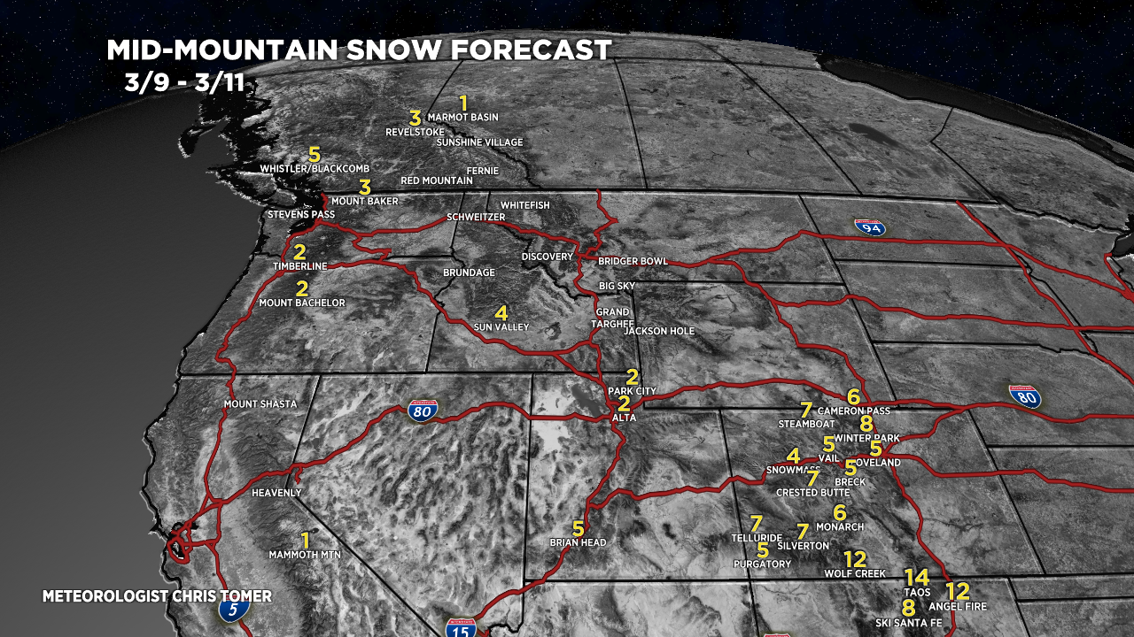
Snow Forecast
3/9-3/11:

3/12-3/15:

3/16-3/18:

Northeast, 3/9-3/18:
90% of this snow occurs on 3/12 with a colder storm system.

For more analysis please watch my forecast video: