Tomer’s Take
- Western storm cycle concludes with a strong, windy, and slower moving storm system.
- High to Extreme wildfire risk precedes this storm system.
- Wind gusts could reach 100mph with blowing dust. A dust layer is possible on the snowpack.
- After 4/24 the pattern shifts. The storm track moves into PNW and turns more tranquil across the Intermountain West with high pressure rebuilding.
Infrared satellite shows the storm track and powerful Pacific storm system lined-up through 4/24.

Wind Gust Forecast
| Gust (MPH) | 4/20 | 4/21 | 4/22 | 4/23 |
| Crestone Peak | 55 | 45 | 90 | 60 |
| Quandary Peak | 45 | 30 | 55 | 55 |
| Kings Peak | 35 | 50 | 55 | 50 |
| Wheeler Peak | 50 | 30 | 65 | 50 |
| Mount Whitney | 55 | 60 | 50 | 30 |
| Grand Teton | 45 | 35 | 30 | 35 |
After 4/24
High pressure rebuilds across the Intermountain West. The storm track and low pressure anomalies shift to the PNW.

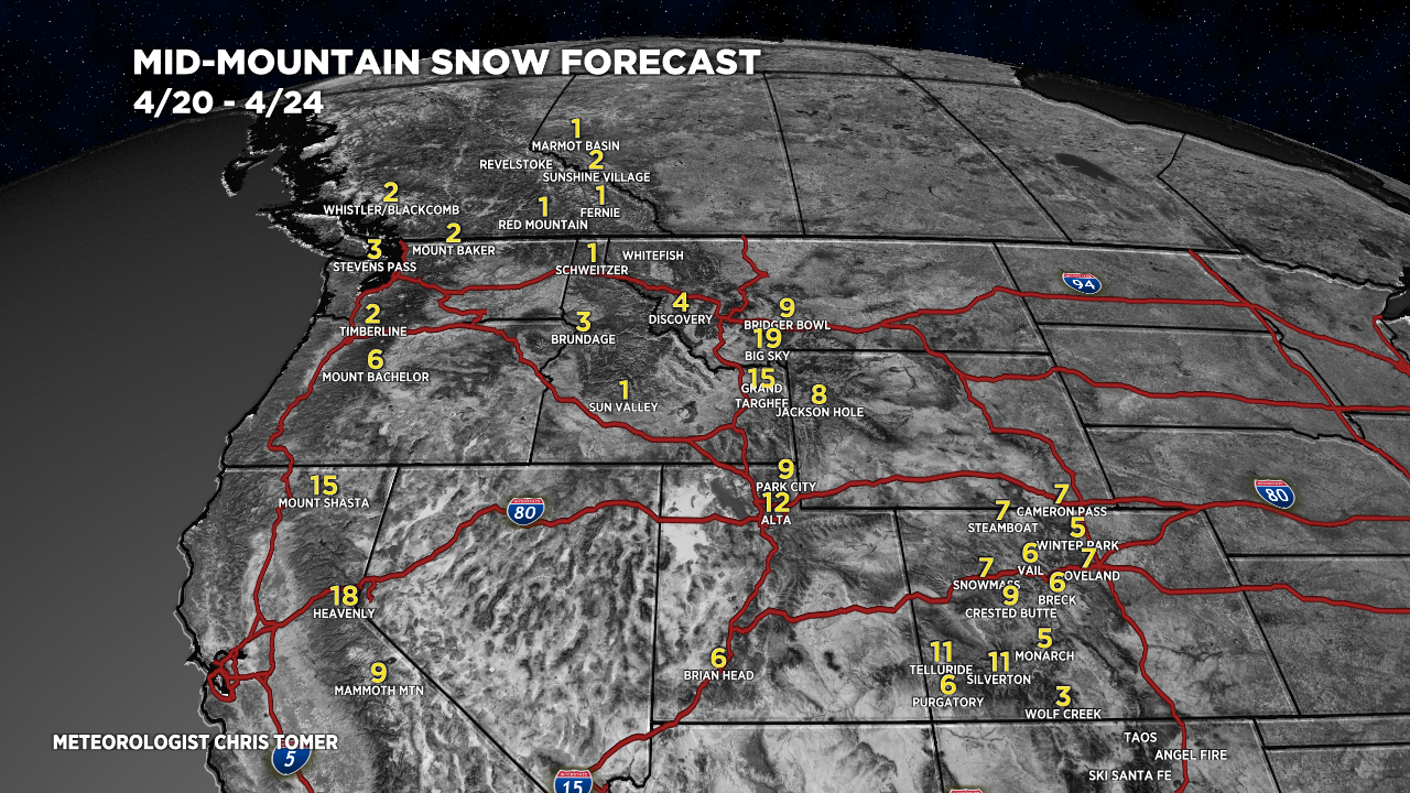
Snow Forecast
4/20-4/24:

4/25-4/29:

Thanks for sharing your detailed analysis with us, Chris!
Thanks, Ivan! Chris
Chris,
Do you think this has been a particularly windy spring? I am debating if my memory of the past spring’s peak bagging missions are clouded by the joys, or if this year really has been significantly windier. I appreciate your forecasting and vlog a bunch!
Thanks!
Thanks, Davis! Yes, it’s been abnormally windy. The blueprint is La Nina driving the jet stream pattern and concurrent wind. La Nina stays in place all of Spring and Summer.
Chris
Very windy and no moisture in castle rock. Lord please send Rain
Thanks, Bonnie!