Tomer’s Take
- The forecast for 1-2 feet materialized across parts of Colorado and Utah.
- Weak to moderate atmospheric river hits Pacific Northwest Friday night-Saturday with 25-50 inches.
- Weak to moderate atmospheric river hits California’s High Sierra 12/12-12/14 with 40-80 inches.
- That storm system then breaks loose and hits Utah, Idaho, Wyoming, SW Montana, and Colorado 12/14-12/15.
Seeing these snowstake cams brings a smile to my face. We needed this snow so bad.


This Weekend
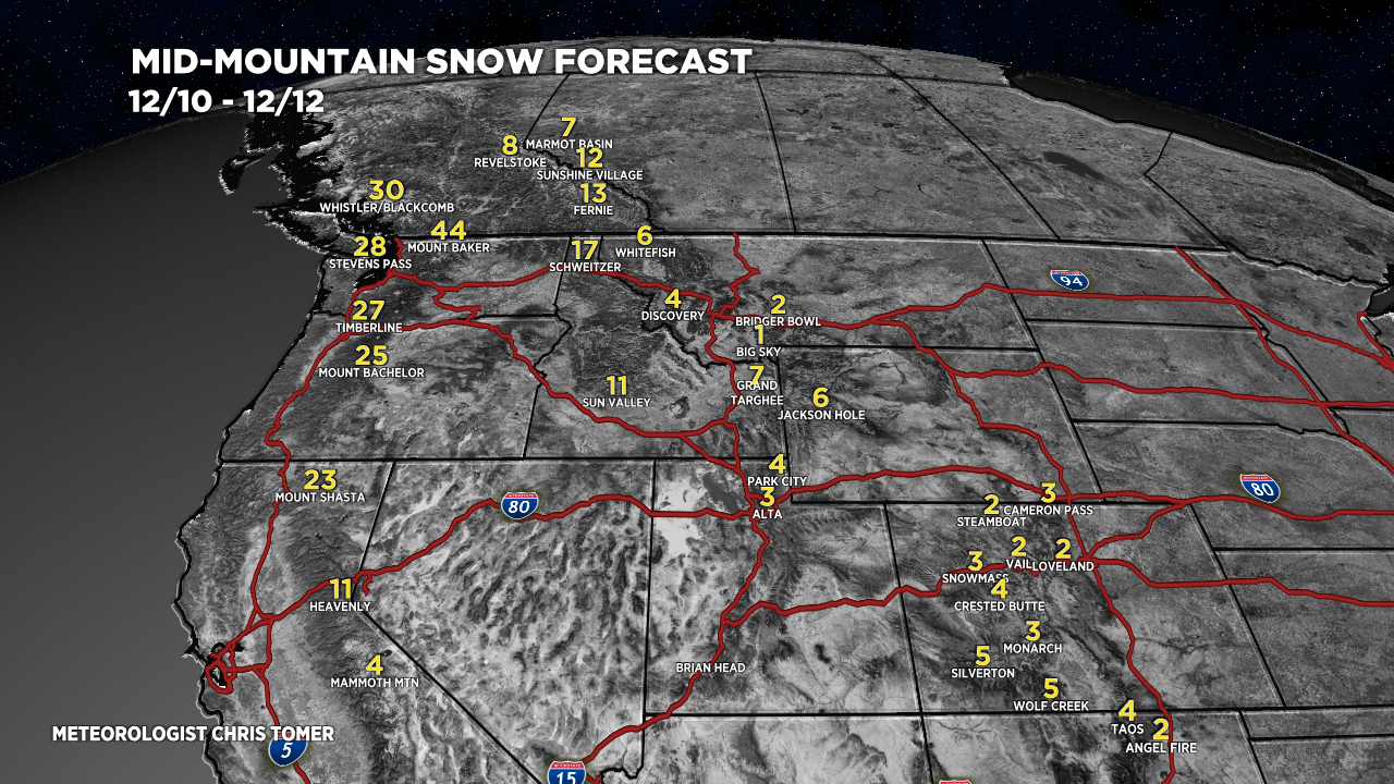
A storm system loaded with a weak to moderate intensity atmospheric river hits the Pacific Northwest between Friday night and Saturday. 25-50 inches of total snow possible on the high volcanoes and high Cascades including Bachelor, Timberline, Stevens Pass, Whistler/Blackcomb, and Mount Baker.
Then, this storm system then sinks south and hits California’s High Sierra with 40-80 inches between Sunday and Tuesday. This includes Shasta, Tahoe, and Mammoth. Here’s the integrated vapor transport forecast for Central California showing the weak to moderate intensity atmospheric river 12/12-12/14.

Snow Forecast
Let’s break my snow forecast into two timeframes.
Mid-mountain totals 12/10-12/12:

Mid-mountain totals 12/13-12/17:

Cold Saturday Morning in Colorado
| 12/11 5am | Wind (mph) | Air Temp (F) |
| Berthoud Pass | 50 | -10 |
| Longs Peak | 70 | -15 |
| Loveland Ski Area | 40 | -14 |
| Cameron Pass | 60 | -8 |
| Quandary Peak | 45 | -20 |

You nailed it!!!
Thanks, Cricket…it was a good storm system now we need more! Chris
Here is a comparison for CB vs WC my fav2
24 hr – CB=24 WC=26
48 hr – CB=29 WC=32
7 day – CB=31 WC=36
The small difference in ridge snow vs butte snow with the same wind and moisture source happening here?
Thanks for the comparison, Randall. More surface area for upslope at WC vs CB. Let’s see what the TUE-WED storm system delivers. Chris
thanks for your forecasts!
Thanks, Judi! Chris