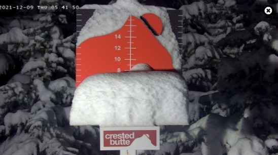
Storm #2 delivered a few pockets of moderate snow accumulation including Crested Butte, Aspen Mountain, and Copper Mountain in Colorado.


The main event for Utah and Colorado remains the 3rd storm system of the cycle. It’s currently exiting California and will move into Utah then Colorado between Thursday and Friday. On infrared satellite also notice the storm system sliding out of the Gulf of Alaska aimed at the Pacific Northwest.

This qualifies as a weak to moderate intensity atmospheric river setup. Heavy snow accumulation (30-50″) likely on the higher volcanoes and Cascades between Friday-Saturday. 8-12″ interior British Columbia and Banff Area.
This storm system and atmospheric river sinks south and hits California by Sunday night and continues Monday and Tuesday. Heavy precipitation totals are likely.

This storm system then breaks loose 12/14-12/15 and delivers snow to Utah, Idaho, Wyoming, Montana, Colorado, and New Mexico. The track of this storm system is still in question and will have important implications on snow accumulation.
Snow Forecast
Let’s look at my snow forecast in two timeframes.
Mid-mountain totals 12/9-12/12

Mid-mountain totals 12/13-12/17.

Drilling down, here’s my snow plume collective.

Cold Morning 12/11
I’m also forecasting the coldest morning of the season so far in Colorado in the wake of this storm system. Let’s look at Saturday (12/11) morning.
| 12/11 5am | GUSTS (MPH) | AIR TEMP (F) |
| LONGS PEAK | 70 | -15 |
| CRESTED BUTTE | 20 | -20 |
| BERTHOUD PASS | 50 | -10 |
| QUANDARY PEAK | 40 | -20 |
| CAMERON PASS | 45 | -8 |
For more analysis here’s my forecast video:
Great to be part of this CT.
Thank you, Jacki! Chris